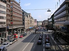
Hamngatan
The Hamngatan is a main road in the district of Norrmalm in Stockholm . The Hamngatan runs in an east-west direction from Nybroplan to Sergels torg .
history
Today's Hamngatan got its name in 1857; in earlier times it consisted of several parts with different names, including a. Styckgjutarebacken (1847), Enkehusgranden (1857) and Hampnegathon (1645).
Hamngatan means "harbor street" and until the 19th century the eastern section of this street was a harbor street. It led down to Nybroviken , a bay in the Baltic Sea that at that time extended further west into the city. Here was a harbor and Stockholm's fish market (now Norrmalmstorg ), where fish are no longer sold. As the land uplifted, the inner part of Nybroviken became swampy and eventually filled up. A park, Berzelii park , was created here around 1850 , named after the Swedish chemist Jöns Jakob Berzelius .
Hamngatan in recent times
Hamngatan changed in the 1960s when Stockholm City was redesigned as part of the redevelopment of Norrmalm and Sveavägen was extended south to Hamngatan. The western part of the street was lowered in order to make an inconvenient slope disappear and widened, whereby numerous culturally and historically valuable buildings were demolished.
The Nordiska Kompaniet (NK) department store , the Gallerian shopping center , Sverigehuset , Kungsträdgården and Norrmalmstorg square are now along the street .
Coordinates: 59 ° 19 ′ 58.7 " N , 18 ° 4 ′ 23.2" E

