Hampton Glacier
| Hampton Glacier | ||
|---|---|---|
|
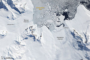
Satellite image of the Hampton Glacier (center right) from 2009 |
||
| location | Alexander I Island , Antarctica | |
| Mountains | Douglas Range | |
| length | 40 km | |
| width | Max. 8 kilometers | |
| Coordinates | 69 ° 29 ′ S , 70 ° 8 ′ W | |
|
|
||
| drainage | Schokalski Bay | |
The Hampton Glacier is a glacier in the northeast of Alexander I Island, west of the Antarctic Peninsula . It flows along the west wall of the Douglas Range in a north-northeast direction to Schokalski Bay .
The first aerial photographs of him were taken during an overflight in 1937 as part of the British Grahamland Expedition (1934–1937) under the direction of the Australian polar explorer John Rymill . Its mouth was measured by the Falkland Islands Dependencies Survey in 1948 . The glacier is named after Wilfred Edward Hampton (1907-1994), participant in Rymill's expedition and pilot of the aircraft with which said overflight was undertaken.
Web links
- Hampton Glacier in the Geographic Names Information System of the United States Geological Survey (English)
- Hampton Glacier on geographic.org (English)

