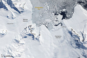
Schokalski Bay
| Schokalski Bay | ||
|---|---|---|
|
Satellite image of Schokalski Bay (2009) |
||
| Waters | George VI Sound | |
| Land mass | Alexander I Island , West Antarctica | |
| Geographical location | 69 ° 17 ′ S , 70 ° 1 ′ W | |
|
|
||
| width | 10 km | |
| depth | 14.5 km | |
| Tributaries | Hampton Glacier , Moran Glacier | |
The Schokalski Bay is a bay that stretches for 10 km between Mount Calais and Cape Brown on the east coast of the Antarctic Alexander I Island . From Hampton glacier huge ice calve over a steep and highly rugged glacier burst into the bay, which is why they do not come as a safe anchorage and the glacier as it as a climbing route to the interior of the island in question.
The bay was first sighted and roughly mapped in 1909 during the Fifth French Antarctic Expedition (1908–1910) under the direction of Jean-Baptiste Charcot . He mistook the bay for a strait and named it after the Russian oceanographer Juli Michailowitsch Schokalski (1856-1940) as Detroit Schokalsky . During the British Grahamland Expedition (1934-1937) led by the Australian polar explorer John Rymill , Charcot's discovery could not be identified. It was not until 1948 that the Falkland Islands Dependencies Survey carried out surveying work that revealed that it must be the bay described here.
Web links
- Schokalsky Bay in the Geographic Names Information System of the United States Geological Survey (English)
- Schokalsky Bay on geographic.org (English)

