
Har Bnei Rasan
| Har Bnei Rasan | ||
|---|---|---|
 Har Bnei Rasan (front right) |
||
| height | 1072 m | |
| location | Israel ( Golan Heights ) | |
| Coordinates | 33 ° 4 '52 " N , 35 ° 50' 2" E | |
|
||
| Development | dirt road | |

The Har Bnei Rasan (German about mountain of restraint , Hebrew הר בני רסן, Arabic تلّ الغسانية, DMG Tall al-Ġassāniyya ) is a mountain in the Israeli- controlled Golan Heights ( northern district ). It has an altitude of 1072 meters above sea level. The only wind farm in Israel, the Har Bnei Rasan wind farm with 10 turbines, is located on the mountain . A public gravel road leads from road 98 up the mountain. The road is in poor condition, but cars can and should be driven on.
Military installations
There are several disused military installations on the mountain. Including several completely preserved bunkers and an underground network of rooms and corridors that can be visited. In addition, there are several fenced off uncleared minefields around and on the mountain .
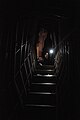
Corridor of the bunker system inside the mountain

Minefield and wind power plant on the mountain


Web links
Individual evidence
- ↑ Archive link ( Memento of the original from August 30, 2000 in the Internet Archive ) Info: The archive link was inserted automatically and has not yet been checked. Please check the original and archive link according to the instructions and then remove this notice.