Haripad
| Haripad ഹരിപ്പാട് |
||
|---|---|---|
|
|
||
| State : |
|
|
| State : | Kerala | |
| District : | Alappuzha | |
| Sub-district : | Karthikapally | |
| Location : | 9 ° 17 ' N , 76 ° 27' E | |
| Residents : | 15,588 (2011) | |
Haripad ( Malayalam : ഹരിപ്പാട് Harippāṭ [ ˈhaɾipːaːɖ ], also Harippad ) is a small town in the Indian state of Kerala .
Haripad is located in the Alappuzha district in southern Kerala. The city is located in the coastal hinterland around 30 kilometers south of Alappuzha and 55 kilometers north of Kollam . The distance to the coast of the Arabian Sea is around six kilometers. The National Highway 66 and the railway line from Alappuzha to Kollam run through Haripad . Haripad is the capital of the Taluk Karthikapally .
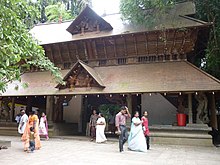
There are two important Hindu temples in Haripad: the Subrahmanya Swamy temple, which is dedicated to the god Subrahmanya , and the Mannarasala temple, in which the snake deities (cf. Naga ) are venerated. Both temples are built in the typical Keralesian style.
According to the 2011 census, Haripad has 15,588 inhabitants. 84 percent of the population are Hindus , 8 percent each are Muslims and Christians .
Individual evidence
- ↑ Census of India 2011: Haripad.
- ^ Census of India 2011: C-1 Population By Religious Community. Kerala.

