
Hasestrasse (Osnabrück)
| Hasestrasse | |
|---|---|
|
|
|
 |
|
| Beginning of Hasestraße with Angersbrücke | |
| Basic data | |
| city | Osnabrück |
| district | Downtown |
| Connecting roads | Erich Maria Remaque Ring |
| Cross streets | Vitihof, Mühlenstrasse, Lohstrasse, Jakobstrasse |
| Places | Cathedral courtyard , market , Great Cathedral Freedom |
| Buildings | Episcopal Chancellery |
| use | |
| User groups | Cars, trucks, cyclists, pedestrians |
| Road design | band Aid |
| Technical specifications | |
| Street length | 400 m |
The Hasestraße is a road south-north-runs in through the Old Town in Osnabrueck. It starts at Erich-Maria-Remarque-Ring and ends at the intersection in front of the cathedral.
location
Hasestrasse, which runs in north-south direction, is the central traffic axis of the northern old town in the city center district. Several side streets branch off mainly to the west, while in the east there is continuous development except for Mühlenstraße and the streets leading to the Große Doms Freiheit . Directly at the northern end of the Erich-Maria-Remarque-Ring runs the Hase , which is crossed with the Angers Bridge.
Development
Angers Bridge

The bridge over the Hase, built in 1914, got its name in 1967 as part of the twinning between Osnabrück and the French city of Angers . It spans the hare with four arches made of sandstone blocks. One of the oldest hares used to be located here, which was later replaced by the previous bridges of the current Angers Bridge. The Angers Bridge was renovated in 2013 because it was heavily affected by traffic, especially buses. A new reinforced concrete relief slab was installed to relieve the vaults of the bridge.
Hasetor
The Hasetor, one of the city gates of the Osnabrück city fortifications, used to be located on the Angers Bridge. After the gate was demolished, the name was retained for the intersection of today's federal highway 68 . There was also an excise house here, which was demolished in 1913 to allow the railway tracks on the Rheine-Löhne line to be raised. As a result of the elevation, the level crossing at the Hasetor crossing could be replaced by a bridge and the long closing times of the barriers were eliminated.
On the opposite side of the road where Hasestraße joins the Ring is the train station, which was called Hasetor from 1895 until it was renamed in 2009. Since it was renamed in 2009, it has been called the Osnabrück Altstadt stop .
Northern Hasestrasse
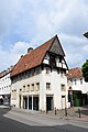
The townhouses from the 16th and 17th centuries, which were once formative before the air raids on Osnabrück , were almost completely destroyed in the northern part of Hasestraße. Only the building at Hasestraße 61 remained here as a half-timbered house from the 17th century.
Hasetor film theater
The Hasetor film theater is located directly on the Angers Bridge. The cinema opened in May 1960 on the site of the Steinhage hotel and dance hall that had been destroyed in the war.
Southern Hasestrasse
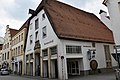
In the southern Hasestrasse, some of the original buildings have survived despite the destruction in the Second World War. The old buildings at Hasestraße 35–37, 41, 45, 26 can be found here, which are considered architectural monuments. The house with number 26 has, among other things, a stone work .
Rampendahl brewery
The house brewery Rampendahl is located in house number 35. The gable of the house is one of the few gables in Osnabrück that was built according to the baroque architectural style. Here, too, a former stone works is integrated into the building. The sidewalk runs through an arcade between the Rampendahl and the neighboring houses .
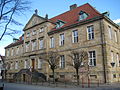
Episcopal Chancellery
The Episcopal Chancellery is located at the southern end of the street at the intersection with the Markt , Domhof and the Große Doms Freiheit . The sandstone building at Hasestraße 40A originally served the Prince-Bishop of Osnabrück as a country and justice office.
gallery

Hasetor film theater
Hasestrasse 41

Hasestrasse 45
Rampendahl brewery with arcades
Episcopal Chancellery


Web links
literature
- Christian Kämmerer: Monuments in Lower Saxony, City of Osnabrück 32nd 1986, ISBN 978-3827182500 .
Individual evidence
- ↑ https://www.noz.de/lokales/osnabrueck/artikel/41633/uberraschungen-bei-sanierung-der-angersbrucke-in-osnabruck-erwartet#gallery&0&0&41633 in Neue Osnabrücker Zeitung on May 10, 2013: "Surprises during renovation the Angersbrücke in Osnabrück expected "; accessed on October 11, 2018
- ↑ https://www.noz.de/lokales/osnabrueck/artikel/98028/das-kleine-finanzamt#gallery&0&0&98028 In Neue Osnabrücker Zeitung on December 6th, 2011: "Das kleine Finanzamt"; accessed on October 11, 2018
- ↑ https://www.noz.de/lokales/osnabrueck/artikel/29306/vom-porno-zum-programm-kino#gallery&0&0&29306 In the Neue Osnabrücker Zeitung on February 3, 2012: "Vom Porno- zum Programm-Kino"; accessed on October 11, 2018
Coordinates: 52 ° 16 ′ 45.1 ″ N , 8 ° 2 ′ 36.4 ″ E