Heissafjord
| Heissafjord | ||
|---|---|---|
|
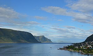
View of the Heissafjord from the east |
||
| Waters | Breisundet | |
| Land mass | Islands of Heissa and Sula | |
| Geographical location | 62 ° 26 '54 " N , 6 ° 8' 35" E | |
|
|
||
| width | approx. 2 km | |
| depth | approx. 5.5 km | |
| Greatest water depth | 106 m | |
| Islands | Storholmen and various archipelago | |
| Tributaries | Borgundfjord | |
The Heissafjord ( Norwegian Heissafjorden ) is a fjord in the Norwegian province of Møre og Romsdal .
It reaches a depth of up to 106 meters and is about 5.5 kilometers long and about 2 kilometers wide. The fjord stretches in a west-east direction between the northern island of Heissa and the southern western part of the island of Sula . To the west, the Breisundet joins the open sea , into which the Valderhaugfjord also flows from the north and the Sulafjord from the south . The Borgundfjord connects to the east . At the northeast end is the access to the port of Ålesund , which is just a little further north .
The municipality border runs through the fjord between Ålesund municipalities in the north and Sula municipality in the south. Langevåg is located on the south bank of the fjord . At its eastern end, there are various archipelagos in the fjord around the island of Storholmen . At the western end on the south side is the small Eltraskjeret archipelago .

