Helenensee (Rinteln)
| Helenensee | ||
|---|---|---|

|
||
| Helenensee near Rinteln | ||
| Geographical location | Lower Saxony , Rinteln | |
| Places on the shore | Rinteln | |
| Data | ||
| Coordinates | 52 ° 12 '2 " N , 9 ° 3' 34" E | |
|
|
||
| Altitude above sea level | 52.7 m | |
| surface | 6.5 ha | |
| Maximum depth | 3.5 m | |
| Middle deep | 2 m | |
|
particularities |
former gravel pit |
|
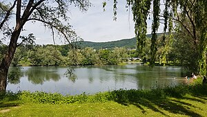
The Helenensee is a former gravel pit northwest of Rinteln in the Schaumburg district . It consists of two partial lakes that are only connected to one another when the water level is higher. The mesotrophic lake lies in the natural flood plain of the Weser and is located north of the river.
The lake was created in the 1950s and 1960s through gravel mining. After the end of its use as a gravel pit, the 16.5 hectare site was sold in 1968 and converted into a recreational area with a campsite . Later this was developed into the Helenensee recreation area. Today there are weekend houses , mobile homes as well as a camping and tent site on the grounds of the recreation area .
The recreation area is bounded by agricultural land and a small forest area. In the south it borders on the Elze – Löhne railway line, known as the Weserbahn, and in the east on an industrial park. A bathing island is anchored in the western part of the lake, which is used as a bathing and fishing lake. In the eastern part there is a natural island and a swimming area with a sandy beach on the southeastern shore.
Web links
- Helenensee , Bathing Water Atlas Lower Saxony
Individual evidence
- ↑ Helenensee: First cattle pasture, then gravel pit - now a recreation area , Schaumburg-Lippische Landes-Zeitung , August 16, 2009. Retrieved April 19, 2018.
- ^ Helenensee recreational area , Schaumburg district. Retrieved April 18, 2016.
