Hernando de Soto Bridge
Coordinates: 35 ° 9 ′ 10 ″ N , 90 ° 3 ′ 50 ″ W.
| Hernando de Soto Bridge | ||
|---|---|---|
| use |
|
|
| Crossing of | Mississippi River | |
| place | Memphis (Tennessee) - West Memphis ( Arkansas ) | |
| construction | Truss - arch bridge | |
| overall length | 1981 m | |
| width | 27 m | |
| Longest span | 2 × 274 m | |
| completion | 1973 | |
| location | ||
|
|
||
The Hernando de Soto Bridge is a six-lane highway bridge , the Interstate 40 between Memphis (Tennessee) and West Memphis ( Arkansas ) over the Mississippi River leads.
It is named after the Spanish explorer Hernando de Soto , who led an expedition through some of today's southern states of the USA from 1539 until his death in 1542 and possibly died south of Memphis.
The Hernando de Soto Bridge, opened in 1973, and the Memphis & Arkansas Bridge (1949), some three kilometers downstream, are the only road bridges between Memphis and the other bank of the Mississippi. The next bridge downstream is the Helena Bridge (1961) at Helena-West Helena , Arkansas , about 110 miles away by road, the closest upstream is the Caruthersville Bridge (1976), 165 km away .
Because of the importance of traffic to the Hernando de Soto Bridge, a program has been running since 2000 that aims to upgrade the bridge and its access roads to such an extent that it can withstand an earthquake measuring 7.7 on the Richter scale .
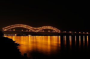
The two main openings in front of the eastern bank are spanned by two large trussed arches with spans of 274 m (900 ft) each, from which the deck is suspended. The two arcs are read as a capital "M" in Memphis, which is why the M-Bridge is also used. At night the outlines of the arches are illuminated. In order not to irritate the skipper with the light reflections in the water, the lighting can be switched off by remote control.
Steel girder bridges on concrete pillars connect to the arches on both sides.
The Hernando de Soto Bridge is 1981 m (6500 ft) long, calculated from its western abutment to the transition structure on Mud Island in front of the actual city area of Memphis. This is followed by an independent bridge structure for distributing the lanes , which extends over the Wolf River into the city to over N 3rd Street and is a further 894 m (2933 ft) long, so that a total length of 2875 m (9433 ft) would result. To the west of the bridge, Interstate 40 crosses the 4 km wide flood bed on two long earth dams and two shorter concrete bridges. The occasionally mentioned length of 5954 m seems to correspond to the length from the first abutment on the western river dike ( Mississippi Levee ) over the entire flood bed, the river and Mud Island to the expansion joint east of N 2nd Street, which is then followed by the Ramp bridge connects east of N 3rd Street to the abutment .
Web links
Individual evidence
- ↑ Hernando de Soto Bridge on Historic Memphis Bridges
- ↑ Hernando DeSoto Bridge on Bridghunter.com
- ↑ Hernando de Soto Bridge on the website of John A. Weeks III


