
Hidaka-Sanmyaku-Erimo-Quasi-National Park
|
Hidaka-Sanmyaku-Erimo-Quasi-National Park
|
||
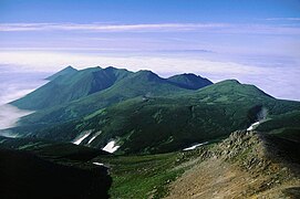
 Mount Kamui |
||
| location | Hokkaidō , Japan | |
| surface | 1,034.47 km² | |
| WDPA ID | 12287 | |
| Geographical location | 42 ° 23 ' N , 142 ° 57' E | |
|
||
| Setup date | October 1, 1981 | |
| administration | Hokkaido Prefecture | |

The Hidaka-Sanmyaku-Erimo-Quasi-National Park ( Japanese 日 高 山脈 襟 裳 国 定 公園 , Hidaka-sanmyaku Erimo Kokutei-kōen ) is a quasi-national park in Hokkaidō , Japan . The park, founded on October 1, 1981, covers an area of approx. 1034 km², which is divided into three areas:
- the Hidaka Mountains: approx. 1,500 m - 2,000 m
- two stretches of coast (at Cape Erimo )
With the IUCN Category II, the park area is classified as a national park . The Hokkaidō Prefecture is responsible for the management of the park.
Flora and fauna
At the foot of the Hidaka Mountains there are many coniferous forests, as well as deciduous and mixed forests. Flower species such as carnation and Lilium pensylvanicum can be found along the coastal road . A population of Kuril sea dogs ( Phoca vitulina stejnegeri ) lives at Cape Erimo .
gallery
Mount Sakai as seen from Tokachi

Angelica acutiloba subsp. iwatensis

Kuril sea dog


