Hochbrücke (Munich)
Coordinates: 48 ° 8 ′ 10 ″ N , 11 ° 34 ′ 45 ″ E
| High bridge | ||
|---|---|---|
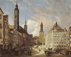
| Valley with high bridge, painting by Ferdinand Jodl, 1835 | ||
| use | Road bridge | |
| Convicted | Salt road Bad Reichenhall - Lake Constance | |
| Subjugated | Katzenbach | |
| place | Munich | |
| construction | from 1395 stone arch bridge , from 1860 wooden bridge | |
| completion | First mentioned in 1322 | |
| Status | departed | |
| closure | Early 20th century | |
| location | ||
|
|
||
The high bridge was a bridge over the Katzenbach in Munich , which was closed at the beginning of the 20th century.
location
The bridge was in the valley at the point where the salt road crossed the Katzenbach. Instead of the brook, the Radlsteg run to the south and the Hochbrückenstrasse to the north.
After the first city expansion of Munich at the beginning of the 13th century, the Kaltenbachtor was located in the inner city of the bridge (the Katzenbach was still called Kaltenbach at that time ). Down the stream, next to the bridge, lay the baker's tower and behind it the Hochbruckmühle.
history
In 1322 the bridge was first mentioned as Bruck auf dem Kaltenbach . From 1395 it is called the Hochbruck . This is interpreted to mean that it was "arched" at that time, that is, it was built as a stone bridge with a brick vault . In writing, however, it is only described as arched in a bridge index from 1562 . Next to the bridge was a horse pond . Since the residents complained that accidents occurred again and again in winter due to the steep incline and the slipperiness, the bridge was demolished in 1860 and rebuilt as a level wooden bridge. At the beginning of the 20th century the Katzenbach was completely arched, so that the bridge lost its function.
literature
- Christine Rädlinger : History of the Munich bridges . Ed .: City of Munich, Construction Department. Verlag Franz Schiermeier, Munich 2008, ISBN 978-3-9811425-2-5 , p. 22, 29, 246 .
- Helmuth Stahleder : House and street names in Munich's old town . Hugendubel, Munich 1992, ISBN 3-88034-640-2 , p. 680-685 .

