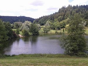
Flood retention basin Diebach
| Flood retention basin Diebach | |||||||||
|---|---|---|---|---|---|---|---|---|---|
| View over the Diebachsee from the dam to the north | |||||||||
|
|||||||||
|
|
|||||||||
| Coordinates | 48 ° 59 '39 " N , 9 ° 42' 35" E | ||||||||
| Data on the structure | |||||||||
| Construction time: | until 1974 | ||||||||
| Height above foundation level : | 17 m | ||||||||
| Building volume: | 140 000 m³ | ||||||||
| Crown length: | 200 m | ||||||||
| Data on the reservoir | |||||||||
| Storage space | 0.48 million m³ | ||||||||
The Diebach flood retention basin is located on the northern edge of the village of Fichtenberg in the municipality of the same name. This is located in the southwest of the Schwäbisch Hall district in Baden-Württemberg . The basin is also called the Fichtenberg / Diebachtal or Diebachsee retention basin .
The reservoir was built for flood protection and dams the Diebach , a left tributary of the lower Fichtenberger Rot in the Swabian-Franconian Forest Nature Park . Later it was made into a natural recreation area. In summer it is used as a swimming lake and in winter for ice skating. The recreation center at the lake includes a bathing area, changing rooms, toilets, a children's playground, tennis courts, a beach volleyball field, a football field, a barbecue area, a circular hiking trail, parking spaces and a restaurant.
The owner of the flood retention basin is the Fichtenberger Rot water association.

