Homa Bay
| Homa Bay | ||
|---|---|---|
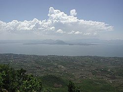
 Homa Bay, photographed from Mount Homa , 2007 |
||
| Basic data | ||
| county | Homa Bay County | |
| surface | 197 km² | |
| Inhabitants - population density |
32,174 inh. 163 inh / km² |
|
| height | 1330 m | |
| Homepage of Homa Bay | ||
| Coordinates | 0 ° 31 ′ S , 34 ° 27 ′ E | |
|
|
||
Homa Bay is a town of about 33,000 people on the south bank of Lake Victoria in Kenya . Homa Bay is the capital of the county of the same name and a Roman Catholic bishopric .
The entrance to Ruma National Park is 30 kilometers from Homa Bay .
climate
The climate in Homa Bay is rather dry, interrupted by two rainy seasons per year. Long-lasting rain falls between March and May, and between September and November there is always shorter rainfall. The average amount of precipitation is then around 1180 millimeters. The average temperature in Homa Bay is between 26 and 28 degrees Celsius.
Infrastructure
In addition to several primary schools, Homa Bay has ten secondary schools and six colleges . In addition to the state hospital, there is a clinic run by the Roman Catholic Church , a health center run by the Anglican Church and seven private clinics.
traffic
Homa Bay Airport is located eight kilometers southeast of Homa Bay .
