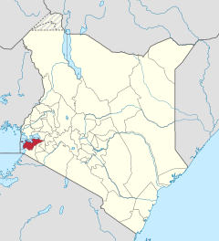
Homa Bay County
| Homa Bay County | |
|---|---|
| Population (state) - population density |
1,131,950 inh. (2019) 359 inh / km² |
| surface | 3,154.7 km² |
| Coordinates | 0 ° 35 ′ S , 34 ° 25 ′ E |
| ISO 3166-2 | KE-08 |

|
|
Homa Bay County (until 2010 Homa Bay District ) is a county in Kenya . The county's capital is Homa Bay . In 2019, 1,131,950 people lived on 3,154.7 km² in the county. 2.7% of households are connected to the electricity grid. The county borders on Lake Victoria . The Ruma National Park is located in the district .
structure
Homa Bay County is divided into two councils and five divisions. There are two constituencies called Ndhiwa and Rangwe.
| Councils | ||||
| Seat of the authority | Art | Population (1999) | ||
|---|---|---|---|---|
| Homa Bay | Borough | 55,532 | ||
| Homa Bay County | county | 233.008 | ||
| total | - | 288,540 | ||
| Divisions | |||
| division | Population (1999) | Capital | |
|---|---|---|---|
| Asego | 76,778 | Homa Bay | |
| Ndhiwa | 43,231 | ||
| Nyarongi | 41,300 | ||
| Rangwe | 79.263 | Rangwe | |
| Riana | 47,968 | ||
| total | 288,540 | - | |
religion
Homa Bay County is the seat of the Homa Bay Diocese of the Roman Catholic Church . The Diocese of Homa Bay was established in 1993. Philip Anyolo was last bishop of the diocese until 2018 .
Individual evidence
- ↑ a b 2019 Kenya Population and Housing Census Volume I: Population by County and Sub-County. KNBS, accessed November 20, 2019 .
- ↑ a b c Statistics on cck.go.ke (PDF) ( Memento from May 30, 2009 in the Internet Archive )
- ↑ Entry on Homa Bay County at catholic-hierarchy.org
Web links
Commons : Homa Bay County - Collection of pictures, videos, and audio files