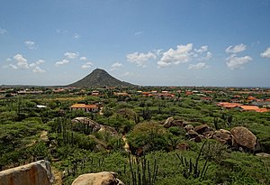
Hooiberg
| Hooiberg | ||
|---|---|---|
| height | 165 m | |
| location | Caribbean island of Aruba | |
| Mountains | former volcano | |
| Coordinates | 12 ° 31 ′ 1 ″ N , 69 ° 59 ′ 42 ″ W | |
|
|
||
The Hooiberg is a 165 meter high mountain and district of the same name on the island of Aruba . It is the second highest mountain on the island after the Jamanota .
The mountain got its typical shape of a volcanic cone from the tectonic uplift of the Caribbean plate several million years ago when the Pacific Ocean formed. In principle, it is one of the elevations of a coastal hill range below the sea surface, which extends from Venezuela into the Caribbean Sea.
A staircase with 562 steps leads to the summit and there are several radio and satellite antennas at the top, which are operated by the telecommunications company SETAR . On a clear day you can see the Venezuelan coast from above.
The Hooiberg volcanic cone is part of the Aruba coat of arms as a landmark , as it is located almost in the middle of the island and can be seen from practically anywhere on the island.
literature
- M. Sullivan: Adventure Guide to Aruba, Bonaire & Curaçao. Hunter Publishing, Inc. 2006. page 81 ( online at Google Books )


