Hope Vale Shire
| Shire of Hope Vale | |
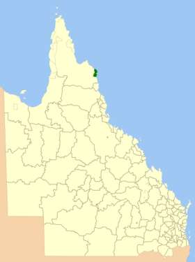
 Location of Hope Vale Shire in Queensland |
|
| structure | |
| State : |
|
| State : |
|
| Administrative headquarters: | Hope Vale |
| Dates and numbers | |
| Area : | 1,107.1 km² |
| Residents : | 976 (2016) |
| Population density : | 0.9 inhabitants per km² |
Coordinates: 15 ° 18 ′ S , 145 ° 7 ′ E The Aboriginal Shire of Hope Vale is a local government area (LGA) in the Australian state of Queensland . The area is 1107 km² and has about 1000 inhabitants.
geography
The Shire is located on the east coast of the Cape York Peninsula in the north of the state about 190 km north of Cairns and 1580 km north of the capital Brisbane .
Almost all residents live in the Hope Vale settlement in the south of the LGA.
history
The first mission station was built on Elim Beach in the 1880s to accommodate indigenous people. During the Second World War, the Aborigines were brought to Woorabinda and after the war in 1949 today's Hope Vale Mission was built. In 1986 it was given to the Aborigines and eleven years later they were granted 110,000 hectares of land on the coast to manage. In 2004 the Hope Vale Shire was founded and local self-government was granted to the indigenous people.
administration
The Hope Vale Council has five members. The Mayor and four other Councilors are elected by all residents of the Shire. The LGA is not divided into electoral districts.
Web links
Individual evidence
- ↑ a b Australian Bureau of Statistics : Hope Vale (S) ( English ) In: 2016 Census QuickStats . June 27, 2017. Retrieved May 14, 2020.