
Hortobágy-Berettyó
| Hortobágy-Berettyó | ||
|
|
||
| Data | ||
| location | Hungary | |
| River system | Danube | |
| Drain over | Körös → Tisza → Danube → Black Sea | |
| origin | Transition in the area of the Hortobágyi National Park from the Hortobágy 47 ° 21 ′ 25 ″ N , 21 ° 1 ′ 48 ″ E |
|
| muzzle | at Mezőtúr in the Körös coordinates: 46 ° 56 ′ 26 ″ N , 20 ° 38 ′ 13 ″ E 46 ° 56 ′ 26 ″ N , 20 ° 38 ′ 13 ″ E
|
|
| length | 167.3 km | |
The Hortobágy-Berettyó is a predominantly artificial watercourse that is largely formed from the Hortobágy and flows into the Körös at Mezőtúr , it has a total length of 167.3 km.
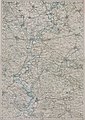
Muzzle into the Körös (N 46 ° 56 '; E 38 ° 18') around 1892 (record sheet of the Franzisco-Josephinische Landesaufnahme )

Web links
Hortobágy-Berettyón on www.origo.hu , accessed on December 24, 2013
Individual evidence
- ↑ Hortobágy-Berettyó on http://horgaszvizkatalogus.hu , accessed on December 24, 2013