Hozameen Range
| Hozameen Range | |
|---|---|
| location | Canada ( British Columbia ), USA ( Washington ) |
| part of | Northern Cascade Range |
| Coordinates | 49 ° 15 ′ N , 121 ° 0 ′ W |

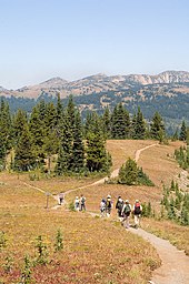
The Hozameen Range (in the United States Hozomeen Range is written) is a mountain range in southwestern British Columbia (Canada) and in the northern part of the US state of Washington , which is the geographical border between the coastal and the inland region of British Columbia. It is a sub-chain of the Northern Cascade Range and lies in the vicinity of the Okanagan Range in the east and the (unofficially so-called) Coquihalla Range in the northwest, which lies between the river of the same name and the Fraser River . In the northwestern part of the Hozameen Range is its only named partial chain, the Bedded Range .
geography
There are differences of opinion about the location and boundaries of the sub-chains of the Northern Cascade Range, although the early geologists and topographers basically agreed on this. The Hozomeen Range was then bounded by the Skagit River in the west and extended eastward to the Pasayten River (east of the Sumallo River ) and the Coquihalla River . According to this definition, the core of the Hozomeen Range marks the watershed between the rivers in British Columbia that flow westward to the Fraser River and those that flow over long distances via tributaries of the Nicola River , Thompson River and Similkameen River either into or into the Fraser Okanogan River flow. This early nomenclature defined the Hozomeen Range as crossing the US-Canadian border southwards and included the peaks of the area around Hozomeen Mountain .
BCGNIS defines the chain as extending to the Coquihalla River in the south and the Tulameen River and Pasayten River in the west ; to the west it is bounded by the Skagit Range .
Peakbagger.com defines the Hozameen Range as bounded to the west by the Skagit River, to the northwest by the Coquihalla River, to the northeast by the Tulameen River and to the east by the Similkameen River.
tourism
The EC Manning Provincial Park is located entirely within the boundaries of Hozameen Range.
Individual evidence
- ↑ a b Fred Beckey : Climbing and High Routes: Rainy Pass to Fraser River (= Cascade Alpine Guide), 3rd edition, The Mountaineers , 2009, ISBN 978-0-89886-423-6 .
- ↑ Hozameen Range . In: BC Geographical Names (English)
- ↑ Hozameen Range . peakbagger.com. Retrieved August 10, 2009.