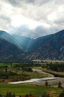
Similkameen River
| Similkameen River | ||
|
The Similkameen River near Keremeos , British Columbia |
||
| Data | ||
| Water code | US : 1525806 | |
| location |
British Columbia ( Canada ), Washington ( USA ) |
|
| River system | Columbia River | |
| Drain over | Okanagan River → Columbia River → Pacific Ocean | |
| source | in EC Manning Provincial Park 49 ° 12 ′ 36 ″ N , 120 ° 51 ′ 2 ″ W |
|
| muzzle | south of Oroville in Washington (USA) in the Okanagan River Coordinates: 48 ° 53 ′ 30 " N , 119 ° 25 ′ 49" W 48 ° 53 ′ 30 " N , 119 ° 25 ′ 49" W |
|
| Mouth height |
276 m
|
|
| length | 251 km | |
| Catchment area | 9300 km² | |
| Drain |
MQ |
85 m³ / s |
| Left tributaries | Tulameen River | |
| Right tributaries | Pasayten River , Ashnola River | |
| Reservoirs flowed through | Enloe Dam | |
| Communities | Eastgate, Princeton , Hedley, Keremeos, Cawston | |
The Similkameen River is a river in the south of the Canadian province of British Columbia , which flows south of Oroville in the US state of Washington into the Okanagan River ; it thus belongs to the system of the Columbia River .
The river has its source in EC Manning Provincial Park in the Cascade Range , the winding course of the valley is followed by British Columbia Highway 3 ( Crowsnest Highway ) to the reservation of the Lower Similkameen Band; the border with the USA is crossed south of Keremeos at ( ⊙ ). The river separates the main chain of the Cascade Mountains from the Okanagan Range and this from the Thompson Plateau . The Similkameen River's main tributaries are the Pasayten River , Tulameen River, and Ashnola River .
Web links
- Similkameen River . In: BC Geographical Names (English)
- Similkameen River in the United States Geological Survey's Geographic Names Information System
