Huamantla
| Huamantla | ||
|---|---|---|
|
Coordinates: 19 ° 19 ′ N , 97 ° 55 ′ W Huamantla on the map of Tlaxcala
|
||
| Basic data | ||
| Country | Mexico | |
| State | Tlaxcala | |
| Municipio | Huamantla | |
| City foundation | 1534 | |
| Residents | 92,887 (2015) | |
| City insignia | ||
| Detailed data | ||
| height | 2497 m | |
| Time zone | UTC −6 | |
| Feria with street decorations made of colored sawdust | ||
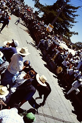
| Bull running (encierros) in the streets of the Huamantlada | ||
Huamantla ( Nahuatl roughly: 'place of trees standing together') is a city in the Mexican state of Tlaxcala in central Mexico . Huamantla was recognized as a so-called Pueblo Mágico (magical place) by the SECTUR (Secretariat for Tourism in Mexico).
Huamantla has a population of over 50,000 and is the administrative seat of the Municipio Huamantla .
history
- Post-classical period: Otomí migrate from Chiapan, today on the territory of the state of México, to Huamantla, according to the Codex Huamantla.
- 1847: Battle of Huamantla, during the US invasion of Mexico.
geography
Huamantla is located in the central Mexican plateau, interrupted to the southwest by the inactive Malintzin volcano, about 15 km away .
Culture
Huamantla is a Mexican center for bullfighting. At one of the most important folk festivals ( Huamantlada ) bull runs (encierros) take place. An international festival of puppet shows is also held in Huamantla. At Easter there is a colorful festival (Feria), during which the streets of the city are paved with patterns made of colored sawdust ( Alfombras de aserrín ).
Web links
- Enciclopedia de los Municipios y Delegaciones de México: Huamantla (Spanish)


