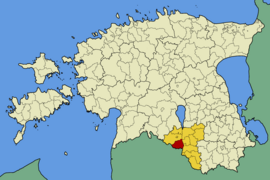
Hummuli
| Hummuli | |||
|
|||
| State : |
|
||
| Circle : |
|
||
| Coordinates : | 57 ° 54 ' N , 26 ° 3' E | ||
| Area : | 162.7 km² | ||
| Residents : | 1,060 (2006) | ||
| Population density : | 7 inhabitants per km² | ||
| Time zone : | EET (UTC + 2) | ||
| Website : | |||

|
|||
Hummuli (German: Hummelshof ) is a rural community in the Estonian district of Valga with an area of 162.7 km². It has 1060 inhabitants (January 1, 2006).
In addition to the main town Hummuli (432 inhabitants), the municipality includes the villages of Aitsra, Alamõisa, Jeti, Kulli, Piiri and Puide.
Hummuli was first mentioned in a document in 1226 in a partition agreement between the Bishop of Tartu and the Teutonic Order ( Terra Humularia ).
Hummelshof manor house
The history of the Hummelshof manor goes back to at least 1470. Here took place on July 19, 1702, during the Great Northern War , between the armies of the Swedish King Charles XII. and the Army of the Tsar of Russia , Peter the Great , the battle of hummelshof instead. The current building dates from the 1860s when the property belonged to the noble Samson von Himmelstjerna family, who remained in their possession until 1914. Today there is a school in the manor house.


