Ilha de Tinharé
| Ilha de Tinharé | ||
|---|---|---|
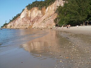
| Praia da Argila near Gamboa | ||
| Waters | Atlantic Ocean | |
| Geographical location | 13 ° 30 ′ S , 38 ° 58 ′ W | |
|
|
||
| length | 23.1 km | |
| width | 14.5 km | |
| Street in Gamboa | ||
The Ilha de Tinharé is a Brazilian island in the Atlantic . It belongs to the municipality of Cairu in the state of Bahia in Brazil .
location
Tinharé is less than a kilometer from mainland Brazil near Valença . Immediately south of it is the Ilha de Boipeba , and to the west the Ilha de Cairu . The island extends 23.1 km in north-south direction and reaches its greatest width in the north with 14.5 km, the south of the island is only 5 km wide.
Infrastructure
The island's main port is Morro de São Paulo on the northern tip of the island. The island can be reached by ferry. Morro de São Paulo is served several times a day in a 20-minute flight with an Aereo taxi. The catamaran takes about two hours. No motor vehicle traffic is permitted anywhere on the island.
Worth seeing
- Dilapidated fortress from 1630. In 1822 it was the base of the English Lord Cochrane , who supported Brazil in the War of Independence.
- Nossa Senhora da Luz church from the 19th century.
- Convent of Santo Antônio
- Lighthouse (monument protection)
Web links
Commons : Ilha de Tinharé - collection of images, videos and audio files


