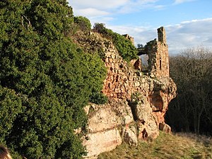
Innerwick Castle
| Innerwick Castle | ||
|---|---|---|
|
Innerwick Castle ruins |
||
| Creation time : | 14th Century | |
| Castle type : | Spurburg | |
| Conservation status: | ruin | |
| Standing position : | Scottish nobility | |
| Construction: | Quarry stone | |
| Place: | Innerwick | |
| Geographical location | 55 ° 57 '19.6 " N , 2 ° 25' 31.8" W | |
| Height: | 70 m ASLTemplate: height / unknown reference | |
|
|
||
Innerwick Castle is a ruined castle near the village of Innerwick and about 5 miles from Dunbar in the East Lothian administrative division of Scotland . The ruin is on the Thornton Burn stream above the Thornton Glen .
The castle was built in the 14th century on "the edge of a steep valley" and was a fortress of the Stuarts and the Hamiltons . Innerwick Castle was expanded several times, but then in 1548 by Edward Seymout, 1st Duke of Somerset , captured and destroyed. Both Innerwick Castle and Thornton Castle were strategically important in securing the roads from the south.
Innerwick Castle is in the Baronate of Innerwick. The last Baron Innerwick was Colonel Victor Charles Vereker Cowley of Crowhill (1918-2008). Today Thornton Glen is part of the Crowhill Estate and is managed by the Scottish Wildlife Trust . The valley is considered an important habitat for fern species rare in Scotland . The remains of the castle lie on a cliff that is popular with rock climbers.
Web links and sources
- Robert Chambers: The Gazetteer of Scotland: Innerwick . Balfour and Jack, 1836. p. 575.
- Innerwick, East Lothian in A Vision of Britain Through Time . JISC - University of Portsmouth.
- James Paterson: History of the county of Ayr . Thomas George Stevenson, Ayr 1852. p. 230.
- Adam and Charles Black (Firm): Black's Picturesque Tourist of Scotland . 1852. p. 155.

