Isangel
| Isangel | ||
|---|---|---|
|
|
||
| Coordinates | 19 ° 33 ′ S , 169 ° 17 ′ E | |

|
||
| Basic data | ||
| Country | Vanuatu | |
| ISO 3166-2 | VU | |
| Residents | 1248 (2010) | |
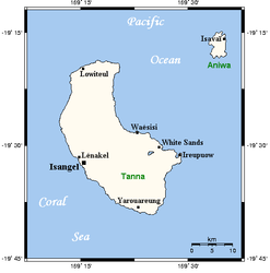
Isangel is the capital of the Tafea province of the island state of Vanuatu . It is located on the west coast of the island of Tanna .
geography
Isangel is located on a hill above the west coast, on a north-west foothill of Mount Tukosmera and is connected to the coastal road by spur roads. The nearest towns are Lenakel (NW) and Bethel (S). The place has large buildings and has 1248 inhabitants.
history
From 1985 to 1994 the place was the capital of the "island" province of Taféa .
climate
|
Average monthly temperatures and rainfall for
Source: en.climate-data.org
|
||||||||||||||||||||||||||||||||||||||||||||||||||||||||||||||||||||||||||||||||||||||||||||||||||||||||||||||||||||||||||||||||||||||||||||||||||||||
