
Tafea
| Tafea | |
|---|---|

|
|
| geography | |
| Country: | Vanuatu |
| Waters: | Pacific Ocean |
| Islands: | 8th |
| Geographical location: | 19 ° 30 ′ S , 169 ° 30 ′ E |
| Basic data | |
| Surface: | 1628 km² |
| Residents: | 32,540 |
| Population density: | 20 inhabitants / km² |
| Capital: | Isangel |
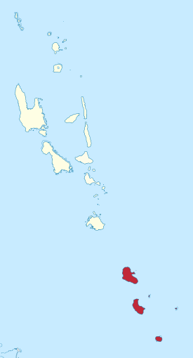
| Situation map | |
  |
|
Tafea is the southernmost province of the South Pacific island state of Vanuatu . The region includes the main islands of Tanna , Aniwa , Futuna , Erromango and Aneityum , as well as some smaller islets, and connects to the province of Shefa in the north .
As well as the names of the other five provinces is Tafea a portmanteau formed from the initials of the province forming main islands or island groups, here T anna, A niwa, F utuna, E rromango and A N atom.
Today 32,540 people live on a land area of 1628 km² (as of the 2009 census ). The provincial capital Isangel is located on the west coast of Tanna.
| island | main place | Area km² |
Population 2009 |
summit | Height (meters) |
Coordinates |
|---|---|---|---|---|---|---|
| T anna | Isangel | 565 | 28,799 | Mount Tukosmera | 1.084 | 19 ° 29 ′ 15 ″ S , 169 ° 19 ′ 50 ″ E |
| A niwa | Ikaokao | 8th | 341 | . | 42 | 19 ° 15 ′ 1 ″ S , 169 ° 36 ′ 4 ″ E |
| F utuna | Mohoun'gha | 11 | 535 | Tatafou | 666 | 19 ° 31 ′ 47 ″ S , 170 ° 13 ′ 8 ″ E |
| E rromango 1) | Potnarvin | 975 | 1950 | Mount Santop | 886 | 18 ° 48 ′ 50 ″ S , 169 ° 7 ′ 22 ″ E |
| A neityum 2) | Anelgauhat | 162 | 915 | Mount Inrerow Atahein | 852 | 20 ° 11 ′ 18 ″ S , 169 ° 49 ′ 34 ″ E |
| Tafea | Isangel | 1,721 | 32,540 | Mount Tukosmera | 1.084 | 19 ° 30 ′ S , 169 ° 30 ′ E |
1) including Vete Manung (Île de la Chèvre, Goat Island) (5.6 km northeast, 12 ha area)
2) including Inyeug (0.6 km southwest, Aneityum airport), but without the remote, controversial Matthew and Hunter Islands , which are considered property by the residents of Aneityum