Ambrym
| Ambrym | ||
|---|---|---|
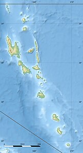
| Ambrym (marked in red) and neighboring islands in the satellite image | ||
| Waters | Pacific Ocean | |
| Archipelago | New Hebrides | |
| Geographical location | 16 ° 15 ′ S , 168 ° 7 ′ E | |
|
|
||
| surface | 678 km² | |
| Highest elevation | Mount Marum 1334 m |
|
| Residents | 7275 (November 16, 2009) 11 inhabitants / km² |
|
Ambrym is an island in the New Hebrides, part of the oceanic state of Vanuatu, in the southwestern Pacific. It is one of the three main islands of the province of Malampa and the fifth largest island in the country and measures 678 km². About 7000 people live on Ambrym. Because the interior of the island is strongly shaped by the local volcanoes, settlement and agriculture are concentrated on the coastal zone.
geography
Ambrym is centrally located within the main group of the New Hebrides, about 170 km north of Vanuatu's capital Port Vila and about 2000 km northeast of Australia. On its east side, the island is surrounded by the open Pacific Ocean , on the other side is the Coral Sea . Ambrym has a distinctive triangular shape: three peninsulas of roughly the same size and very similar in shape are attached to the mountainous core area of the island in the west, north and east. The east-west extension of the island is 43 km, from north to south it measures 30 km.
In the center of Ambrym the volcanoes rise to over 1300 m above sea level. A lava landscape with no vegetation extends around them for many kilometers . The lower-lying regions near the coast have tropical vegetation. The natural vegetation is predominantly dense jungle ; the numerous coconut plantations represent the most important type of land use and one of the main sources of income on Ambrym.
Volcanism
Vanuatu is in a zone of high volcanic activity, as this is where the Pacific and Australian plates meet.
From a geological point of view, the island of Ambrym itself is one huge shield volcano . It represents the most voluminous volcano in all of Vanuatu. In the center of the island is a 12 by 8 km large caldera , which was created almost 2000 years ago as a result of a massive magnitude 6 eruption . Around 70 cubic kilometers of material were emitted, which corresponds to about six times the amount of Pinatubo emissions in 1991 .
The two volcanic cones Benbow and Marum formed in the caldera . Both cones are still active; as early as 1774, James Cook noticed the violent volcanism on Ambrym on his second voyage to the South Seas.
In the 20th century, too, powerful eruptions occurred several times, which caused great damage to the island. In 1913/14, 1929 and 1950 there were devastating outbreaks that destroyed entire villages. The 1913/14 eruptions were the most violent in Melanesia for 400 years. Lava lakes formed in ten eruptions in recent history .
The volcano has been active almost continuously since 1996.
history
The first European explorer to see Ambrym was the French circumnavigator Louis Antoine de Bougainville in 1768. Cook passed the island six years later, but only landed on the neighboring island of Malakula to the west , where he also met men from Ambrym.
During the particularly destructive volcanic eruption of 1913, the people of Ambrym had to flee to the neighboring islands.
languages
Different languages are spoken regionally on Ambrym. These include Dalkalaen , Daakaka and Daakie in the west of the island . In the north and south-east, Northern Ambrym is spoken with local varieties.


