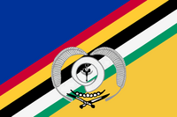
Torba (Vanuatu)
| Torba | |
|---|---|

|
|
| geography | |
| Country: | Vanuatu |
| Waters: | Pacific Ocean |
| Islands: | 21st |
| Geographical location: | 13 ° 45 ′ S , 167 ° 30 ′ E |
| Basic data | |
| Surface: | 882 km² |
| Residents: | 9359 |
| Population density: | 11 inhabitants / km² |
| Capital: | Sola |
| Situation map | |
Torba is the northernmost province of the South Pacific island state of Vanuatu . The province includes the Torres Islands and the Banks Islands , the latter including the small group of Rowa Islands (Reef Islands) and the small, somewhat remote Vétaounde Island. In the south of Torba the provinces of Sanma and Penama join.
As with all (of the six) provinces of Vanuatu also the name is derived Torba of the name of the main islands or groups of islands located in the region, here the To rres Islands, the R owa Islands and the Ba nk Islands, from.
About 9359 people live on a land area of 882 km². The provincial capital Sola on Vanua Lava in the archipelago of Banks Island area, has about 1000 inhabitants.


