Banks Islands
| Banks Islands | ||
|---|---|---|
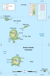
| Topographic map of the Banks Islands | ||
| Waters | Pacific Ocean | |
| Geographical location | 13 ° 55 ′ S , 167 ° 34 ′ E | |
|
|
||
| Number of islands | approx. 20 | |
| Main island | Vanua Lava | |
| Total land area | 780 km² | |
| Residents | 8533 (2009) | |
| This statue was found in the Banks Islands | ||
The Banks Islands are the northeastern archipelago of the South Pacific island state of Vanuatu . Together with the further northwestern Torres Islands in the northwest, they form the Vanuatu province of Torba , with six of the seven municipalities of the province on the Banks Islands. The total area of the islands is almost 780 km².
geography
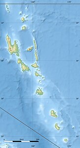
![]() Map with all coordinates: OSM | WikiMap
Map with all coordinates: OSM | WikiMap
For archipelago of Banks Island are some of the larger islands of Vanuatu, especially Vanua Lava and Gaua . The capital of the Vanuatu province of Torba, Sola , is located on the southeast coast of Vanua Lava.
The Atoll Rowa in the northeast and the small island Vétaounde, somewhat remote in the north, also belong to the Banks Islands.
The most important islands with name, area and population:
| Island name | Area (km²) |
population | main place | summit | Height (meters) |
local community | Geocoordinate |
|---|---|---|---|---|---|---|---|
| Vétaounde (Vatganai, Vot Tande, Vet Tagde) | 0.24 | - | - | ... | 76 | Mota Lava | 13 ° 16 ′ S , 167 ° 39 ′ E |
| Ureparapara (Bligh Island) | 39 | 437 | Léar (Léséréplag) | Mount Tow Lap (Tooulap) | 764 | Uréparapara | 13 ° 32 ' S , 167 ° 20' E |
| Vanua Lava | 330 | 2623 | Sola | Mount Suretamate | 921 | Vanua Lava | 13 ° 48 ′ S , 167 ° 28 ′ E |
| Ravenga | 0.5 | - | - | ... | ... | Vanua Lava | 13 ° 47 ' S , 167 ° 33' E |
| Kwakéa | 1.15 | 29 | - | ... | ... | Vanua Lava | 13 ° 53 ' S , 167 ° 36' E |
| Niwula | 0.4 | - | - | ... | ... | Vanua Lava | 13 ° 53 ' S , 167 ° 37' E |
| Mota (Sugarloaf Island) | 9.5 | 683 | Veverao | Mount Tawe | 411 | Mota | 13 ° 51 ' S , 167 ° 42' E |
| Mota Lava | 31 | 1451 | Lahlap | Mount Tuntog | 243 | Mota Lava | 13 ° 39 ′ S , 167 ° 42 ′ E |
| Ra (Aya) | 0.5 | 189 | Ra | ... | ... | Mota Lava | 13 ° 43 ' S , 167 ° 37' E |
| Mere Lava (Star Peak Island) | 15th | 647 | Tasmate | Mount Teu (Star Peak) | 833 | Mere lava | 14 ° 27 ' S , 168 ° 4' E |
| Gaua (Santa Maria Island) | 330 | 2491 | Jolap | Mount Garat | 767 | Gaua | 14 ° 16 ′ S , 167 ° 31 ′ E |
| Mérig (Vergel Island, Île Sainte Claire) | 0.5 | 12 | Lévolvol | ... | 125 | Mere lava | 14 ° 19 ′ S , 167 ° 48 ′ E |
| Rowa Islands (Reef Islands) | 0.1 | - | - | ... | 2 | Mota Lava | 13 ° 37 ′ S , 167 ° 31 ′ E |
| Banks Islands | 782 | 8,562 | Sola | Mount Suretamate | 921 | 6 municipalities | 13 ° 55 ' S , 167 ° 34' E |
Today, 8533 people speak 15 different languages on the islands of the group.
Web links
- Mario Maffi and Brian Taylor: The mosquitoes of the Banks and Torres Island Groups of the South Pacific, 1977 (with descriptions of the islands; English; PDF; 1.5 MB)
- Alternative island names
Individual evidence
- ↑ Current and Historical Island Names PDF, (English)
- ↑ http://horizon.documentation.ird.fr (PDF; 2.2 MB)
- ↑ a b 2009 National Census of Population and Housing: Summary Release (PDF), Vanuatu National Statistics Office, 31-08-2009.
- ↑ linguistic map of the Torres and Banks Islands


