Ureparapara
| Ureparapara | ||
|---|---|---|
| Ureparapara satellite image | ||
| Waters | Coral sea | |
| Archipelago | Banks Islands | |
| Geographical location | 13 ° 32 ′ 0 ″ S , 167 ° 20 ′ 0 ″ E | |
|
|
||
| length | 8.3 km | |
| width | 7.7 km | |
| surface | 39 km² | |
| Highest elevation | Mount Tow Lap 764 m |
|
| Residents | 437 (November 16, 2009) 11 inhabitants / km² |
|
| main place | Reading pla | |
|
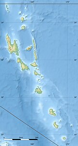
Banks Islands, Ureparapara top left |
||
Ureparapara (formerly Bligh Island ) is after Gaua and Vanua Lava the third largest island of the Banks Islands in the north of the Pacific island state of Vanuatu , which administratively belong to the province of Torba .
geography
The island's old volcanic crater was eroded by the sea to the east, forming Divers Bay (Lorup Bay) . Apart from this 3.7 km deep and 1.4 km wide indentation, the island is almost circular with a diameter of around eight kilometers. The highest point on the island is Mount Tow Lap (Tooulap) with 764 meters, which is located on the crater rim.
The island is 39 km². In 1979 the population was 239. Newer sources from 2009 give a population of 437.
There are three villages on the island. The main town is Léar (Léséréplag). The others are Lehali (on the west coast) and Lequanle (Lekwyangle, on the northwest coast). A current (2015) map source names two more villages called Kowe and Tano , also in the northwest.
languages
Two languages are spoken on the island, Löyöp (in the main town of Leserepla on Divers Bay in the east, 240 speakers) and Lehali (in the villages of Lehali and Lequanle in the west and northwest, 200 speakers). On Lehali the island is called Noypēypay [nɔjpejˈpaj] , and on Löyöp Aö [aˈø] .
media
- Ureparapara is the setting for the documentary film Description of an Island by Rudolf Thome , which was released in Germany in 1978 .
Individual evidence
- ↑ Unep Islands
- ↑ 2009 National Census of Population and Housing: Summary Release (PDF), Vanuatu National Statistics Office, 31-08-2009.
- ↑ Vincent Lebot and Pierre Cabalion: Les Kavas de Vanuatu , p. 83 ( online in the Google book search)
- ↑ Mario Maffi and Brian Taylor: The Mosquitoes Of The Banks And Torres Island Groups Of The South Pacific (Diptera: Culicidae) (PDF; 1.5 MB)
- ↑ [1]
- ↑ ethnologue.com on the Löyöp language
- ↑ ethnoloue.com on the Lehali language
- ↑ Detailed list and map of the Bank and Torres languages .
- ↑ Description of an island at filmportal.de


