Mérig
| Mérig | ||
|---|---|---|
| NASA satellite image of Mérig | ||
| Waters | Coral sea | |
| Archipelago | Banks Islands | |
| Geographical location | 14 ° 19 ′ 0 ″ S , 167 ° 48 ′ 0 ″ E | |
|
|
||
| length | 800 m | |
| surface | 50 ha | |
| Highest elevation | 125 m | |
| Residents | 12 (2009) 24 inhabitants / km² |
|
| main place | Lévolvol | |
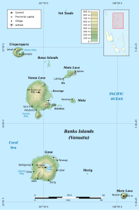
| Map of the Banks Islands with Mérig below | ||
Mérig or Merig , formerly also Vergel Island or Île Sainte Claire , is a small island in the archipelago of the Banks Islands in the north of the Pacific island state of Vanuatu . Administratively, the island, like all the Banks Islands, belongs to the province of Torba .
geography
Mérig is about halfway between Gaua in the west and Mere Lava in the east, from which it is 21 km and 26 km away, respectively. The almost round island has a diameter of 800 m, a circumference of 2.2 km and an area of 0.5 km². It is of volcanic origin and reaches a height of 125 m above sea level. Mérig has 12 inhabitants who all live in the village of Lévolvol . The population speaks Mwerlap , a Melanesian language from the group of Oceanic languages .
Individual evidence
- ↑ a b UNEP Islands Directory (English)
- ↑ National Census of Population and Housing 2009 (English; PDF) (accessed December 23, 2010)
- ↑ Linguistic Map of the Banks Islands (accessed December 23, 2010)


