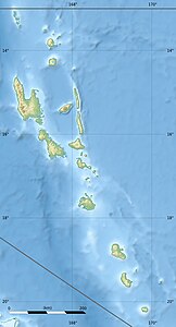
Malacula
| Malacula | ||
|---|---|---|
| Malacula | ||
| Waters | Coral sea | |
| Archipelago | New Hebrides | |
| Geographical location | 16 ° 22 ′ S , 167 ° 32 ′ E | |
|
|
||
| surface | 2,041.3 km² | |
| Highest elevation | Mount Liambele 879 m |
|
| Residents | 20,000 | |
| main place | Lakatoro | |
Malakula is an island in the New Hebrides and the second largest island in the island state of Vanuatu .
geography
About 20,000 people live on Malakula. It is separated from Espíritu Santo and Malo by Bougainville Street . In the north-east of the island are some islands, including Vao, Atchin, Wala, Rano, Norsup, with the largest coconut plantation in the Republic of Vanuatu, as well as Uripiv and Uri. The Maskelyne Islands are offshore in the southeast .
Lakatoro (1200 inhabitants), capital of the Malampa province , is the largest settlement on the island and is located in the east of the island.
The highest point on the island, Mount Liambele, is 879 m above sea level.
history
In 1914 and 1915, the British ethnologist John Layard lived on the small islands off Malakula. He brought back over 400 photo plates and wax rolls with sound recordings from his field research . Originals and copies of the documents are in the Museum of Archeology and Anthropology, University of Cambridge .
linguistics
In addition to the Creole language Bislama , over 20 different, independent languages are spoken on Malakula and the islands.
literature
- Haidy Geismar and Anita Herle: Moving images. John Layard, fieldwork and photography on Malakula since 1914 , Crawford House Publishing Australia, Adalaide, South Australia 2009 ISBN 978-1-86333-3-191
- in bislama
- John Layard long Malakula 1914–1915 , Vanuatu Cultural Center, Port Vila , Vanuatu

