New Hebrides
| New Hebrides | |
|---|---|
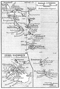
| Map of the New Hebrides from 1905 | |
| Waters | Coral sea |
| Geographical location | 17 ° 0 ′ S , 168 ° 0 ′ E |
| Number of islands | approx. 60 |
| Main island | Espiritu Santo |
| Total land area | 11,307 km² |
| Residents | 178,921 (1999) |
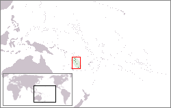
The New Hebrides archipelago is a 700 km long chain of islands in the South Pacific , 300 km south of the Solomon Islands , 460 km northeast of New Caledonia and 960 km west of Fiji .
geography
The 60 or so islands of the New Hebrides are politically part of the island state of Vanuatu . They form the northeastern border of the coral sea to the open Pacific. Espiritu Santo Island is the northernmost and Aneityum is the southernmost island of the New Hebrides.
The nearby archipelagos north and northeast of Espiritu Santo ( Banks Islands and Torres Islands ) do not belong geographically to the New Hebrides, but they do belong to the state of Vanuatu ( Torba Province ).
The same applies to the (politically controversial) Matthew and Hunter Islands south of the New Hebrides .
history
The islands were discovered for Europe by the English navigator James Cook in 1774. The naming probably goes back to the similarity with the appearance of the Scottish archipelago Outer Hebrides .
literature
- Robert Steel: The New Hebrides and Christian missions - With a Sketch of the Labor Traffic and Notes of a Cruise through the Group in the Mission Vessel , London 1880. ( online ).

