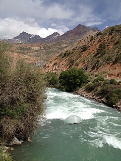
Iskander Darya
|
Iskanderdarja Искандар, Искандердарья́ |
||
| Data | ||
| location | Sughd ( Tajikistan ) | |
| River system | Zerafshan | |
| Drain over | Fandarja → Zerafshan → Karaköl | |
| origin | Lake Iskanderkul 39 ° 4 ′ 56 ″ N , 68 ° 22 ′ 24 ″ E |
|
| Source height | 2195 m | |
| Association with |
Jagnob zum Fandarja Coordinates: 39 ° 11 ′ 21 ″ N , 68 ° 32 ′ 18 ″ E 39 ° 11 ′ 21 ″ N , 68 ° 32 ′ 18 ″ E
|
|
| length | approx. 20 km | |
| Catchment area | approx. 950 km² | |
| Discharge at the Istok gauge ( ⊙ ) A Eo : 760 km²
|
MQ 1936/1985 Mq 1936/1985 |
18.7 m³ / s 24.6 l / (s km²) |
| Communities | Narwad, Dischik, Chaironbed | |
The Iskanderdarja ( Tajik Искандардарё ; Russian Искандердарья́ ) is the left source river of the Fandarja in Tajikistan .
The Iskanderdarja forms the outflow of the moraine lake Iskanderkul . It flows from its northeast bank in a predominantly northeast direction through a mostly narrow gorge of the Hissar Mountains and after about 20 km reaches the Jagnob , with which it unites to form Fandarja.
The Iskanderdarja drains an area of approx. 950 km². At the Istok gauge at the discharge from the Iskanderkul, the mean discharge is 18.7 m³ / s. In June and July the Iskander Darya has the highest drainage.
The settlements of Narwad , Dischik and Chaironbed lie on the river. The access road to Iskanderkul runs through the valley.
Individual evidence
- ↑ a b c UNESCO: Iskanderdarya at Istok (discharge data 1936–1985) ( Memento of the original from March 3, 2016 in the Internet Archive ) Info: The archive link was inserted automatically and has not yet been checked. Please check the original and archive link according to the instructions and then remove this notice.


