Isla de Sacrificios
| Isla de Sacrificios | ||
|---|---|---|
| Isla de Sacrificios | ||
| Waters | Gulf of Mexico | |
| Geographical location | 19 ° 10 '30 " N , 96 ° 5' 32" W | |
|
|
||
| length | 380 m | |
| width | 200 m | |
| surface | 6 ha | |
| Oblique aerial view | ||
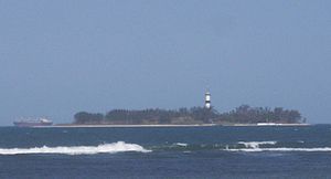
Isla de Sacrificios ( German "Island of the victims" ) is an island in the Gulf of Mexico near the port of Veracruz in Mexico , 1,490 meters from the mainland. The waters around the island are part of the Sistema Arrecifal Veracruzano Marine National Park . The island got its name from the members of the Spanish expedition of 1518 under Juan de Grijalva . According to the report Verdadera Historia de la Conquista de la Nueva España ( True History of the Conquest of New Spain ) by Bernal Díaz del Castillo , a member of the expedition, the Spaniards found clear evidence of human sacrifice . Therefore they named the island Isla de Sacrificios (Island of the Sacrifice). The ships of Hernán Cortés ' fleet gathered in front of this island to prepare to land in the Aztec empire . Archaeological finds from the island are now in the British Museum .
The island is 380 meters long, up to 200 meters wide, and has an area of around six hectares .
Web links
- motecuhzoma.de
- Historical map with Isla de Sacrificios at the bottom
Individual evidence
- ↑ Bernal Díaz del Castillo: History of the Conquest of Mexico, 1988, p. 52


