
Islas Chafarinas
| Islas Chafarinas | ||
|---|---|---|
| Waters | Lake Alborán , Mediterranean | |
| Geographical location | 35 ° 11 ′ N , 2 ° 26 ′ W | |
|
||
| Number of islands | 3 | |
| Main island | Isla de Isabel II | |
| Total land area | 0.52 km² | |
| Residents | 200 (2006) | |
 |
||

The Islas Chafarinas ( Chafarineninseln , Tamazight ⵜⴰⴽⴼⴰⵔⵉⵏⴰⵙ Takfarinas ) are a politically Spain belonging archipelago , about 50 kilometers east of Melilla and only four kilometers from the village of Ras el Ma on the Moroccan lies Coast. The archipelago , which is a plaza de soberanía , consists of the islands Isla de Isabel II , Isla del Congreso and Isla del Rey (Francisco) . The total area of the islands is 52 hectares.
geography
- Isla del Congreso: There is a prison on the largest island in the archipelago , but it is no longer in use. The Cerro Nido de las Águilas is the highest point in the archipelago with a height of 137 meters.
- Isla de Isabel II: The only inhabited island in the archipelago is home to a military station . In addition to the military buildings, there is a church that was built between 1851 and 1853.
- Isla del Rey: The third island of the archipelago has an area of about 12 hectares, is under nature protection and is not inhabited.

Location off the Moroccan coast
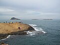
Islas Chafarinas (around 2011)


population
There are no civilians on the islands; only on Isla de Isabel II there is a small military station.
history
The islands were conquered by the Spanish on January 6, 1848, in a race against a French military expedition, which reached the archipelago just a few hours later. Today they are equipped with a garrison , a small harbor and a lighthouse , as well as a bird sanctuary. The name Chafarinas comes from the Berber language and roughly means islands of the pirates .
Web links
- Ejercito.mde.es: Fotografías ( Memento of August 13, 2014 in the Internet Archive )