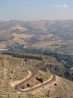
Yarmuk
|
Yarmuk Yarmuk |
||
|
The course of the river through Hauran |
||
| Data | ||
| location | Syria , Jordan and Israel | |
| River system | Jordan | |
| Drain over | Jordan → Dead Sea | |
| origin | Confluence of source rivers from the Jebel ad-Duruz | |
| muzzle | in the Jordan coordinates: 32 ° 38 '52 " N , 35 ° 33' 51" E 32 ° 38 '52 " N , 35 ° 33' 51" E
|
|
| Catchment area | 7000 km² (rounded) | |
| Reservoirs flowed through | Al-Wahda Dam | |
|
A railway bridge over the Yarmuk was destroyed in an attack by the Hagana on the “Night of the Bridges” in 1946 |
||
The Yarmuk (also Yarmuk , Arabic نهر اليرموك Nahr al-Yarmūk , DMG nahru ʾl-Yarmūk , Hebrew נהר הירמוך Nahar haJarmuch , Latin Hieromyces ) is the largest tributary of the Jordan . It forms the border between Syria and Jordan and shortly before the confluence with the Jordan between Israel and Jordan.
course

The source rivers of the Yarmuk arise on the lower southern slope of the Jebel ad-Duruz . The only two perennial (year-round water) tributaries on the Syrian side are the Nahr el-Ehrer (Nahr Harir), which flows in from the north, whose spring supplies 0.2 m 3 / s water, and Wadi Zeidi, whose highest springs around the lake at Mezerib (Muzayrib, 11 kilometers northwest of Dar'a ). In the west and southwest of this village, the Zaizun waterfalls (Shallalat Zaizun) fall spectacularly into the Yarmuk Gorge. The other northern tributaries only carry water during the winter and spring rainy seasons. A third tributary, Wadi esh-Shellaleh (Shallah) flows in from the south.
The basin drained by the Yarmuk has an area of around 7,000 square kilometers. The largest part is made up of the volcanic basalt plain of the Hauran on both sides of the national border. In the further course to the west, the Yarmuk crosses the partial landscape of the Golan (al-Jaulān), where it receives water from the Nahr er-Rukkad, which rises at the foot of the Hermon , and from the year-round water Wadi Masud. Most of the springs arise on both sides of the river at the transition from the basalt plateau of the Hauran to the limestone formations of the southern Golan. The Yarmuk flows in cascades through a deep gorge; shortly before the confluence, the limestone cliffs are up to 300 meters high.
Between 2001 and 2007, Jordan and Syria built the Al-Wahda Dam (“Dam of Unity”). With the 86 meter high dam wall, up to 110 million cubic meters of water can be dammed. The height above sea level at the dam is 72 meters, a few kilometers downstream at the waterfalls of the Wadi Khaled (a station on the Hejaz Railway ), the river has fallen to sea level, the mouth into the Jordan is 250 meters below sea level.
With the influence of the Yarmuk in the Jordan south of the Tiberiases near Naharaim, the first electricity power station Tel-Or ("light mountain") was built in the former Palestine, of which today only the ruins after the destruction in the First Arab-Israeli War can be seen.
history
On August 20, 636, the Battle of Yarmuk took place, in which the Muslim Arabs inflicted a decisive defeat on the troops of the Emperor Herakleios in the course of the Islamic expansion . The battle ultimately led to the loss of the Eastern Roman provinces of the Orient to the Arabs and is therefore of world historical importance.
literature
- Wilhelm Kubitschek : Hieromykes . In: Paulys Realencyclopadie der classischen Antiquity Science (RE). Supplementary volume III, Stuttgart 1918, column 1150 f.
- Naval Intelligence Division (Ed.): Syria. BR 513 (Restricted). Geographical Handbook Series. April 1943. Archive Editions, Buckinghamshire 1987, pp. 51-53
Web links
- David J. Burdon: Infiltration Rates in the Yarmuk Basin of Syria-Jordan. Assemblée Général de Rome II, 1954, pp. 343–355 (PDF file; 928 kB)
Individual evidence
- ↑ a b Geographical Handbook Series, p. 53: 6970 km 2 ; David J. Burdon, p. 343: 7584 km 2
- ↑ Shmuel Avitzur: The Power Plant on two Rivers . (English)


