Jesus Trail
| Jesus Trail | |
|---|---|

|
|
| Data | |
| length | 65 km |
| location | Galilee in northern Israel |
| Markers |

|
| Starting point |
Nazareth 32 ° 42 ′ 7.4 " N , 35 ° 17 ′ 51.6" E |
| Target point |
Capernaum 32 ° 52 ′ 50.9 " N , 35 ° 34 ′ 28.7" E |
| Type | trail |
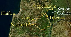
The Jesus Trail (sometimes also called Jesusweg ) is a 65 km long pilgrimage or hiking trail in Galilee in northern Israel . It is laid out on a route that Jesus could have walked because it connects numerous places of his life and work. The trail begins in Nazareth , the largest Arab city in Israel, and goes through Sepphoris , Kana (Arabic: Kafr Kanna), the Horns of Hittim , the steep slopes of Mount Arbel , the Sea of Galilee , Tabgha , Capernaum and the Mount of Beatitudes . An optional way back leads via Tiberias , past the Jordan , Mount Tabor and Mount Praecipitium (Mount Praecipitium). The path connects places of importance to Christians , Muslims , Jews and Druze . The Jesus Trail runs within the 1967 borders of Israel.
origin


The Jesus Trail was started in 2007 by two hiking enthusiasts, Maoz Inon, a Jewish-Israeli entrepreneur and owner of hostels and accommodation in Israel, and David Landis, a Christian-American hiking expert. It was marked in 2009. Currently, a group of volunteers is promoting and managing the path as a non-profit project.
The trail is open to everyone and camping is permitted in many places. It is marked with a sign made up of three stripes: white, orange, white. If sections of the trail coincide with other hiking trails (for example the Israel National Trail (INT)), an orange circle will also appear.
The biblical basis for the Jesus Trail is a quote from the Gospel of Matthew , according to which Jesus, at the beginning of his ministry, went from his hometown Nazareth in the mountains of Galilee to Capernaum, a fishing village on the shores of the Sea of Galilee, where he gathered his first disciples around him . The Gospel of Matthew says: “He left Nazareth to live in Capernaum, which is on the lake” (Mt 4:13 standard translation).
According to the Gospels, Capernaum became the place of his ministry: “Jesus got into the boat, sailed across the lake and came to his city [Capernaum]” (Mt 9: 1) and “When he returned to Capernaum a few days later, it was known that that he was (again) home "(Mk 2,1)
The Jesus Trail follows the tradition of the classic pilgrimage routes, for example the Way of St. James in northern Spain or the Way of St. Paul in Turkey.
Stages
In terms of landscape and distances, the route can be divided into four day hikes, each 13 to 19 km in length.
From Nazareth to Cana via Sepphoris
The Jesus Trail begins at the Annunciation Basilica in the center of the Arab city of Nazaret, leads through the small old town of Nazaret and climbs up quite steep stairs to the ridge at the top of the city. From there it leads across fields to the ancient city of Sepphoris (Hebrew Zippori) with its extensive excavations. Via the Arab town of Mashad, the path leads to the likewise small Arab town of Kana (Arabic: Kafr Kanna) as the place where, according to New Testament tradition, Jesus turned water into wine ( wedding in Cana ).
From Kana to Kibbutz Lavi
From Kana (Arabic: Kafr Kanna) the path leads mostly along forests and over natural and cultivated fields to the edge of Lavi, a rural Jewish collective settlement (Hebrew kibbutz ), near which the "Horns of Hittim" rise.
This stage leads from hill to hill, first over the horns of Hittim with a wide view over the landscape, past the Druze pilgrimage site of Nabi Schueib in the narrow Arbel valley, through an impressive landscape with a rich history to the Jewish village of Arbel, a modern one agricultural cooperative (Hebrew moshaw ).
From the Moschaw Arbel to Capernaum over the Mount of Beatitudes
After climbing Mount Arbel , the path leads steeply down the slope to a small agricultural plain on the Sea of Galilee. Then the Jesus Trail reaches the north shore of the lake and the Church of the Multiplication in Tabgha , where Jesus fed the five thousand according to the New Testament. Then it leads to the church with a park-like facility on the Mount of the Beatitudes , on which the Sermon on the Mount of Jesus is commemorated, before it ends at the historic fishing village of Capernaum with its extensive excavations and the modern church.
See also
literature
- Jacob Saar: Jesusweg and Jerusalem , Freytag & Berndt 2012. ISBN 978-3-7079-1381-1
- Anna Dintaman, David Landis: Hiking the Jesus Trail and Other Biblical Walks in the Galilee , Village to Village Press, Harleysville, PA, USA, 2010, ISBN 978-0-9843533-0-9

