
Israel National Trail
| Israel National Trail | |
|---|---|

|
|
| Data | |
| length | 1009 km |
| location | Israel |
| Supervised by | Israel Trails Committee (ITC) / SPNI |
| Markers |

|
| Starting point |
Dan 33 ° 14 ′ 22.5 ″ N , 35 ° 39 ′ 12.6 ″ E |
| Target point |
Eilat 29 ° 30 '38.4 " N , 34 ° 55' 17.6" E |
| Type | Long-distance hiking trail |
The Israel National Trail ( Hebrew שביל ישראל Schvil Jisraʾel ), short INT , sometimes just called Israel Trail , is a long-distance hiking trail in Israel .
course
General
The INT stretches for about a thousand kilometers between Dan and Eilat . After several changes to the route, the Society for the Protection of Nature in Israel ( SPNI ) now specifies its length as 1009 kilometers. In other publications deviating length specifications of up to 1100 kilometers can be found. In July 2015, the entire trail was measured and photographed for Google Street View .
The INT runs almost exclusively within the Green Line . The only exception is the Latrun area . There are several alternative routes between Jerusalem and Eilat, which can reduce the total distance to around 820 km. In addition, the trail can be combined with other hiking routes and extended to the Golan Heights and the Hermon . For safety reasons, hikes in this area should be registered with the SPNI .
The INT largely avoids larger towns and cities on its course. Exceptions are e.g. B. Netanya , where the trail runs along the coastal promenade, or Tel Aviv with the Yarkon Park. Interesting cities like Safed , Haifa or Jerusalem can be reached and explored by public transport or extra trails (e.g. the approx. 40 km long Jerusalem Trail ). Smaller towns are often crossed or grazed by the INT so that the supply of water and food is secured. In the Negev , however, it is recommended to secure supplies through taxi services or through previously established depots.

In general, the trail runs on trails of easy to moderate difficulty. However, there are numerous climbing spots where you have to use your hands to help, especially in the Negev, but also in Carmel or Nahal Amud . Steep places are mostly secured. In the Negev, steel ladders up to eight meters high and rope ladders made of wire must be negotiated.
The recommended direction for the trail is north-south in spring and south-north in autumn due to the temperatures in the Negev. The south direction is used for the following description.
route
From Kibbutz Dan the trail runs west to Kirjat Schmona , from there at the height of the Ramim Mountains to the south, past Safed and past the Sea of Galilee near Tiberias . Further west over Mount Tabor , past Nazareth and southeast of Haifa to the Carmel Mountains . Along the western flank of the Carmel it goes south to Zichron Ja'akow and from there to the west. At Jisr az-Zarqa the trail reaches the Mediterranean and runs close to the coast to Tel Aviv. Via Ramla and Latrun it runs in an easterly direction to the western suburbs of Jerusalem, then again to the southwest to Kirjat Gat . From here in a south-easterly direction to Arad , and in the Negev past the Makesh Hagadol and Makesh Ramon craters , along the edge of the Arava Depression to Eilat.
Waymarks


The more than 10,000 km of hiking trails in Israel are marked by a uniform system of signposts. Between two vertical white stripes there is an identification color of the trail; red, blue, green, purple and black are used as identification colors. Branches from the hiking trails that only lead to nearby attractions are only marked with the two white stripes without a color code. These branches are basically dead ends.
The INT is the only hiking trail marked by three stripes in orange, blue and white. Therefore it is also called "TC" (English for triple colored ). Ideally, the stripes are slightly offset from one another in height when they are arranged vertically; the stripe protruding upwards then shows the main direction of the trail. For the south direction the white stripe protrudes downwards, for the north direction upwards. In the case of a horizontal arrangement, the strip on top indicates the main direction. The waymarks are usually placed very clearly and clearly so that they can hardly be missed. However, it can happen during the growing season in spring that they are overgrown by plants. Good maps are therefore recommended. In Israel, specialty shops sell topographic hiking maps, but only in Hebrew script.
In the first few years the INT was only marked with two colors, blue and orange. The main direction of the trail was already recognizable back then by protruding stripes, blue for the north direction and orange for the south direction. Back then, the logo was made up of two intertwined angles in the two colors. The trail is now almost completely marked in the new TC system, old signposts can only be found very sporadically. The old logo, on the other hand, can be found more often on the information boards along the trail.
history

The template for the INT was the Appalachian Trail in the USA. Avraham Tamir (1907–1988), a journalist and author of children's literature, ran the Appalachian Trail in 1980 and was thereby inspired by the idea of setting up a comparable long-distance hiking trail in Israel. He found strong support from the Israel Trails Committee (ITC) and its director, Ori Devir . From 1985 onwards, over several years of work, tourist guides, hikers, nature conservation officers and nature lovers were interviewed and suitable routes were researched from a largely existing network of hiking trails. The INT was drawn up on this basis and created in 1991. On Passover 1995, fifteen years after the idea, the INT was opened in the presence of the then President Ezer Weizmann .
In the year before the official inauguration, Yariv Ya'ari was the first person to hike the entire INT. He needed 21 days for the 900 km long route at the time. Over the years, the INT has become more and more popular with hikers. It is particularly popular with young Israelis, who often run the entire trail after completing their military service.
Due to the expansion of Highway 6 and security risks along the Green Line , part of the INT was relocated within the Sharon Plain to the Mediterranean coast in 2003. As a result, the entire trail length was extended to today's route of approx. 1009 km.
The record (for the old route of about 960 kilometers) is held by the Israeli adventure runner Carlos Goldberg from Ramot Naftali . Goldberg ran the Israel National Trail from north to south in September 2007 in 12 days, 13 hours and 37 minutes.
INT is overseen by the Israel Trails Committee (ITC), a department of the SPNI that maintains a total network of over 10,000 km of hiking trails in Israel.
On October 15, 2019, the Society for Nature Conservation announced a change to the route. It leads from Arad in the Judah desert to the Ramon crater. The aim of the change was to add the Judean Desert , the Dead Sea and Masada to the route of the path. The Israel National Trail will be extended by 50 kilometers.
Attractions
There is a multitude of cultural , geological , botanical , historical and archaeological sights along the INT . The trail often runs through national parks , some of which are subject to entry. It is always possible to bypass these parks, but the bypass paths are not always marked with signposts.
A selection of sights are: Tel Dan , Mount Tabor, Caesarea Maritima , Latrun, Kennedy Memorial , Tel Arad , Machtesch Ramon, ...
safety
One of the main questions about the Israel National Trail and hiking in Israel in general is safety. In more than 21 interviews with Israel Trail hikers, the Israel Trail platform israel-trail.com comes to the conclusion that Israel is generally a very safe travel destination for hikers. A high level of security is therefore also given for women traveling alone or women hiking alone. The outdoor portal israelabenteurer.de provides further comprehensive and up-to-date safety information for Israel adventurers.
Picture gallery

East of Nazareth

South of Hadera
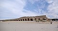
Aqueduct at Caesarea

Along the beach north of Netanya

Burma Road at Latrun

Negev desert

Mountains and bay near Eilat


literature
- Jacob Saar: Israel National Trail. ; Eshkol Publishing Ltd .; ISBN 978-965-91249-4-7
- Eretz Magazine: Hiking in Israel. 36 of Israel's Best Hiking Routes ; The Toby Press LLC; ISBN 978-1-59264-237-3
- Judith Galbum Pex: The Israel Trail. With the backpack through the Holy Land ; Brunnen-Verlag GmbH; ISBN 978-3-7655-1432-6
- Stefan Tomik: Among angels and water thieves. A thousand kilometers on the Israel National Trail ; DuMont travel publisher; ISBN 978-3770182718
- Christian Seebauer: Israel Trail with a heart. The Holy Land on foot, alone and without money ; SCM Hänssler; ISBN 978-3-7751-5706-3
- Christian Seebauer: Israel Trail with a heart. The Holy Land on foot, alone and without money ; NG paperback; ISBN 978-3-492-40496-9
Individual evidence
- ↑ http://www.natureisrael.org/int
- ↑ http://www.jpost.com/Business-and-Innovation/Environment/Google-Street-View-cameras-to-bring-Israel-National-Trail-alive-402038
- ^ The Israel National Trail , accessed December 17, 2016.
- ↑ http://israeltrail.de/israel-national-trail/
- ^ The Israel Trail at SPNI
- ↑ "Israel Trail" leads past Massada. In: Israelnetz .de. October 16, 2019, accessed October 22, 2019 .
- ↑ How safe is it in Israel? - The Israel National Trail . In: The Israel National Trail . June 30, 2015 ( israel-trail.com [accessed September 7, 2017]).
- ↑ 12 Reasons Israel Is Safe . In: Israel Adventurer . September 5, 2016 ( israelabenteurer.de [accessed September 7, 2017]).
Web links
- Israel National Trail (Engl.)
- Israel National Trail (Engl.)
- Israel National Trail at Wikivoyage
- Israel National Trail (Ger.)
- Israel National Trail (Ger.)
- Israel National Trail (Engl.)