Arava
The Arava ( Hebrew הערבה; Arabic وادي عربة, DMG Wādī ʿAraba ; also Aravasenke , occasionally Araba (h) or Aravatal ) is the valley from the Dead Sea to the Gulf of Aqaba , in which the border between Israel and Jordan runs.
Geographical information
The Arava Depression is part of the Great Rift Valley . It extends from the Dead Sea over 165 km to Eilat and Aqaba on the Red Sea and thus represents the continuation of the Jordan Rift to the south. The depression reaches a width of 10 to 25 km. On the eastern edge, the Jordanian mountains rise to a height of over 1700 m near Petra , while the Negev in the west only reaches about 600 m. The Arava Depression itself reaches a height of 230 m at its highest point, which is about 75 km north of the Red Sea. At the Dead Sea, the terrain drops to 417 m below sea level.
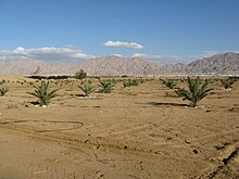
The Arava is a stone desert with little vegetation of perennial shrubs and trees such as sagebrush , camel thorn and other acacias . Like all deserts, however, it is not inanimate. There is even an endemic species of spider named after the Arava Cerbalus aravaensis .
Infrastructure
The Arava has always been a very sparsely populated area. The valley offers good conditions for traffic. In ancient times it was also used in an east-west direction. The incense route from Petra to Gaza on the Mediterranean ran through the Arava. Today traffic through the border is limited to north-south connections.
An important north-south road link has been running on the Israeli side of the valley since 1966 (today: Landstrasse 90 ). This road was the first to cross the entire length of the valley. The continuation along the Dead Sea could only be completed in 1970 with great effort.
Likewise, on the Jordanian side the trunk road R65 (Jordan) runs through the Arava, in the north further on the east side of the Dead Sea and through the Jordan Rift to the border in the Yarmuktal.
In the area of the depression there are no larger places, there are only a few smaller, mostly agriculturally oriented settlements in places where water is available. On the Israeli side, some places are close to the transition between the Negev and Arava mountains, e.g. B. the Kibbutz Jotwata .
meaning
For a long time, copper mining was of economic importance in the Arava: in the southwest on the African plate near Timna (Israel) . The mines existed in ancient times, but mining has now ceased. On the Arabian plate , the copper deposits are 107 kilometers further north in Feinan . These were also exploited as early as the Chalcolithic and up to the 13th century. The distance between the two deposits shows the extent of the displacement of the two continental plates since the African rift valley broke up 35 million years ago, as the copper ore deposit once formed a unit.
In 1994 the Arava Basin was the site of the peace agreement between Israel and Jordan.
research
The Arava is not known on old maps until the 18th century. The Tabula Peutingeriana shows a road from Jerusalem through the edge of the Negev to the Red Sea and in the east the King's Road via Petra and Shobeck to Philadelphia ( Amman ), in between only a crossing south of the Dead Sea. It was not until Johann Ludwig Burckhardt published a map in 1822 on which "El-Araba" is entered.
Scientists from several countries and different disciplines are now participating in the “Wadi Arabah Project” in researching the region. They examine the Arava as a dynamic, historical area that connects southern Jordan with the Negev. This includes the geological formation, flora and fauna, raw material and water deposits as well as settlement structures from the Copper Age to the Ottoman Empire .
Excavations show numerous settlement sites in all epochs. A particularly large number have been identified for the Neolithic and Early Bronze Age . Climate fluctuations have repeatedly had an impact on the population.
Web links
- Homepage of the Wadi Arabah Project
- Wadi Araba Archaeological Research Project
- Aerial photography
- Ulrich Hübner: Araba. In: Michaela Bauks, Klaus Koenen, Stefan Alkier (Eds.): The Scientific Biblical Lexicon on the Internet (WiBiLex), Stuttgart 2006 ff.
literature
- Piotr Bienkowski, Katharina Galor (Eds.): Crossing the Rift: Resources, Routes, Settlement Patterns and Interaction in the Wadi Arabah. Oxbow Books, Oxford 2006, ISBN 978-1-84217-209-4
- Bibliography of the Wadi Arabah Project
Individual evidence
- ^ Geological map
- ↑ Antique Maps
- ^ Participant in the Wadi Arabah Project
- ↑ Maps with settlement density for each epoch
Coordinates: 30 ° 34 ′ 33.2 " N , 35 ° 19 ′ 14.8" E
