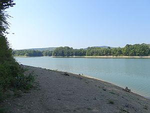
Jezioro Sieniawskie
| Jezioro Sieniawskie | |||||||||||
|---|---|---|---|---|---|---|---|---|---|---|---|
| Jezioro Sieniawskie | |||||||||||
|
|||||||||||
|
|
|||||||||||
| Coordinates | 49 ° 33 '10 " N , 21 ° 55' 56" E | ||||||||||
| Data on the structure | |||||||||||
| Construction time: | 1978 | ||||||||||
| Height of the barrier structure : | 38 m | ||||||||||
| Data on the reservoir | |||||||||||
| Water surface | 1.3 km² | ||||||||||
| Storage space | 14.18 million m³ | ||||||||||
The Jezioro Sieniawskie is a reservoir on the Wisłok in the Polish Subcarpathian Voivodeship . It is located in the Jasło Krosno Basin .
description
Behind the 38 meter high dam the water of Wisłok and smaller tributaries is dammed. When it is completely blocked, the reservoir contains 14.18 million cubic meters of water. The water area is then 1.3 square kilometers.
history
The reservoir was flooded in 1978. It is used both as a swimming lake and as a protective storage against flooding and as a hydropower plant.
tourism
There are several beaches and marinas on the shores of the lake.
Web links
Commons : Jezioro Sieniawskie - collection of images, videos and audio files
literature
- Kęsy Robert i in. 2011. Zbiorniki Wodne w Polsce. Krajowy Zarząd Gospodarki Wodnej, Warszawa, p.44.


