Jintotolo Canal
| Jintotolo Canal | ||
|---|---|---|
| Connects waters | Visayas lake | |
| with water | Sibuyan lake | |
| Separates land mass | Masbate (Philippines) | |
| of land mass | Panay (Philippines) | |
| Data | ||
| Geographical location | 11 ° 42 ′ N , 123 ° 6 ′ E | |
|
|
||
| Smallest width | 40 km | |
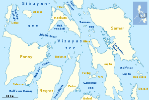
The Jintotolo Canal is a strait in the Philippine archipelago and connects the Visayas Sea in the east with the Sibuyan Sea in the west.
In the north is the island of Masbate , in the south Panay . In the channel itself are the island of Jintotolo in the north and the three small Zapatos islands further south. In the south, the Pilar Bay forms a large sea bulge.
The approximately 40 km wide canal is an important shipping route, which is secured by a lighthouse on the island of Jintotolo. It was built in the 1890s and shows three white flashes every 10 seconds.


