
Johanniterufer
| Johanniterufer | |
|---|---|
|
|
|
 |
|
| Basic data | |
| place | trier |
| District | center |
| Connecting roads | St. Barbara Ufer , Krahnenufer |
| Cross streets | Karl-Marx-Strasse , Krahnenstrasse |
| Buildings | Roman bridge , old customs crane, level house, main customs office |
The Johanniterufer is a street on the edge of Trier city center . It runs along the Moselle between Römerbrücke and Hinter dem Zollamt. In the south, the St. Barbara-Ufer merges directly into the Johanniterufer, which is continued to the north as the Krahnenufer .
history
The name is derived from the Commandery of the Order of St. John , which was located near the Roman bridge. This commandery was taken over by the Knights Templar in 1312 and demolished in 1804.
Cultural monuments
The old customs crane, a pedal crane from the 18th century , stands out among the cultural monuments . There is also an old gauge house on the street. There are also several natural monuments in the street .
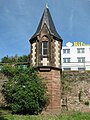
Listed water level house

Former main customs office


literature
- Patrick Ostermann (arrangement): Cultural monuments in Rhineland-Palatinate. Monument topography Federal Republic of Germany. Volume 17.1: City of Trier. Old town. Werner, Worms 2001, ISBN 3-88462-171-8
- Ulrike Weber (edit.): Cultural monuments in Rhineland-Palatinate. Monument topography Federal Republic of Germany. Volume 17.2: City of Trier. City expansion and districts. Werner, Worms 2009, ISBN 978-3-88462-275-9 .
- General Directorate for Cultural Heritage Rhineland-Palatinate (publisher): Informational directory of cultural monuments of the district-free city of Trier. (PDF; 1.2 MB) Koblenz 2010.
- Kulturbüro der Stadt Trier (ed.) / Emil Zenz: Street names of the city of Trier: their sense and their meaning. Trier 2003.
Individual evidence
- ↑ Kulturbüro der Stadt Trier (ed.) / Emil Zenz: Street names of the city of Trier: their sense and their meaning. Trier, 2003.
- ^ Patrick Ostermann (arrangement): Cultural monuments in Rhineland-Palatinate. Monument topography Federal Republic of Germany. Volume 17.1: City of Trier. Altstadt.Werner, Worms 2001
- ↑ Nature Conservation Administration Rhineland-Palatinate: Landscape Information System of the Nature Conservation Administration Rhineland-Palatinate; Retrieved July 29, 2013
Coordinates: 49 ° 45 ′ 10.5 " N , 6 ° 37 ′ 41.7" E