
Jor (Montreux)
| Jor | ||
|---|---|---|
| State : |
|
|
| Canton : |
|
|
| District : | Riviera-Pays-d'Enhaut | |
| Municipality : | Montreux | |
| Coordinates : | 563441 / 145082 | |
| Height : | 1174 m above sea level M. | |
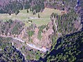
 Aerial view of Jor |
||
| map | ||
|
||

Jor is a place in the municipality of Montreux in the Swiss canton of Vaud at an altitude of 1174 m.
geography
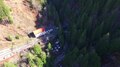
The few buildings in a single location are above Les Avants northeast of Montreux on the road to Col de Jaman . Jor has a stop on the Montreux – Bernese Oberland Railway (MOB) on the Montreux – Lenk line in the Simmental . It is located directly west of the Jaman tunnel at 1084 m. The Baye de Montreux stream rises above Jor and is crossed by the railway on a bridge between the Jaman tunnel and the bus stop.
The 1910 Geographical Lexicon of Switzerland lists 37 inhabitants. Until 1919, Jor was shown on the national map as Chargiau , which describes a suitable place for loading carts .

Jor stop
Video of the Jor stop
Aerial view of Jor with the bus stop


Web links
Individual evidence
- ↑ a b Jor (VD) - Montreux , on map.geo.admin.ch , in a historical view until 1919 Chargiau, from 1920 Jor, height information based on a map from 2014.
- ^ Charles Knapp, Maurice Borel, Victor Attinger, Heinrich Brunner, Société neuchâteloise de geographie (editor): Geographical Lexicon of Switzerland . Volume 6: Tavetsch Val - Zybachsplatte, supplement - last additions - appendix . Verlag Gebrüder Attinger, Neuchâtel 1910, p. 565, keyword Jor ( scan of the lexicon page ).
- ^ Henri Jaccard: Essai de toponomie , G. Bridel, Lausanne 1906, p. 100 .