
King Wilhelm Canal

The King Wilhelm Canal (Lithuanian Karaliaus Vilhelmo kanalas or Vilhelmo kanalas , formerly Klaipėdos kanalas ) is a canal on the north coast of the Curonian Lagoon in today's Lithuania , which was completed in 1873. It served to connect the Memel directly with the port city of Memel / Klaipėda and thus avoid the previously necessary, sometimes dangerous journey across the lagoon. To do this, it connects the Minge (according to Minija ), which in turn flows into the Memel Delta , directly with the port of Klaipėdas. The canal is no longer used for shipping today.
history

Rafting played an important role on the Memel in earlier times . The wood felled in the upper course was transported down the Memel and partially pre-processed on the lower course. Large quantities had to be transported to the former centers of Königsberg and Memel / Klaipėda, which were used to organize further transport (especially from Klaipėda, also by sea across the Baltic Sea ).
After Klaipėda there was a natural waterway from the mouth across the Curonian Lagoon. (There was no such natural connection in the direction of Königsberg, which is why an artificial waterway, the Friedrichsgraben system , was built much earlier .) However, the route across the Curonian Lagoon was quite unsafe because it had to be used to circle the Windenburger Eck . Here a moraine extends far into the lagoon. With south and south-westerly winds one ran the risk of being thrown onto the stone and gravel bank lurking under water; in north-westerly and north-westerly winds one could drive onto the lagoon under the protection of the headland, but then at the level of the lighthouse in the swell of the open water, which could build up over 20-30 km of wind .
The place was considered problematic and, depending on the weather conditions, could hinder transport or lead to sometimes considerable losses in rafting. Since there was no insurance on wooden rafts, the merchants ran high risks; in the autumn storms of October 1862 rafts worth around 70,000 thalers failed at this point. The Windenburger Eck was also considered dangerous for normal shipping.
In order to bypass this point, a first canal was planned as early as the 18th century, but not built for financial reasons, as some merchants preferred to put their cutting mills in the Memel Delta. It was not until the 19th century that the need for sawn timber increased so much that construction was discussed again.
Another plan from 1858 first saw a canal to Dreverna; In 1860, however, the planning was extended directly to what was then the Klaipėdas wooden port near the village of Schmelz / Smeltė .
Construction of the canal began in 1863, and the first planning section from Minge to Dreverna had been completed by 1865. The construction took a total of ten years and was completed after 1870 by the massive deployment of French prisoners of war. The construction cost almost a million thalers. The waterway was named after the Prussian King and later German Emperor Wilhelm I.
Initially, rafts and ships were mainly grained, using a towpath along the eastern Minge and western banks of the canal. In 1902 the canal was deepened to make it usable for larger steamships .
Over time, the canal lost its importance and is no longer in operation as a waterway. At the mouth of Klaipėda a memorial commemorates the French prisoners of war who died while the canal was being built.
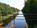
Wilhelm Canal, view to the south

Wilhelm Canal in 1944


course
The beginning of the canal is at Lankupiai on the Minija, about 17 km from its confluence with the Atmata (an estuary of the Memel). The only lock in Lithuania is located there . This was mainly used to keep the spring floods away from the canal, but is now out of order.
After about 13 kilometers there is already a connection to the lagoon via Dreverna - at this point you have already bypassed the Windenburger Eck. After another nine kilometers, the canal then flows into the port area of Klaipėda. Today the canal is separated from the lagoon by a wall and serves as a water reservoir for the city.
literature
- Mohr: The King Wilhelm Canal near Memel . In: Deutsche Bauzeitung . Edition of Thursday, February 29, 1872. Volume 4, Berlin 1872, pp. 67-69.
- Uwe Rada: The Memel. Cultural history of a European river. Siedler Verlag, Berlin 2010. ISBN 978-3-88680-930-1 .
(Contains mainly information about rafting on the Memel, the canal itself is not discussed there.) - Ernst Thomaschky: Northern East Prussia and Memelland. Wasserwanderführer, self-published in 1933, reprint by Verlag Gerhard Rautenberg, Leer 1989 (reprint 1993), ISBN 3-7921-0420-2 , pp. 53-55 (short description and kilometering of the canal for paddlers and rowers; German place names and Gothic script)
Web links
- King Wilhelm Canal , GenWiki
Individual evidence
- ↑ a b c the König Wilhelm Canal in GenWiki
- ↑ the Windenburger Eck in GenWiki - topographical description and citations from historical sources
- ↑ a b c http://www.memelland-adm.de/koenigwilhelmkanal.html
- ↑ a b Information brochure of the J. Gižas Museum Dreverna, Klaipedos rajono turizmo infromacijos centro filialas J. Gižo etnografine sodyba