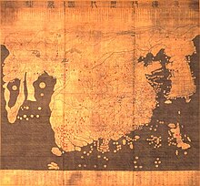
Kangnido card
The Kangnido map , or Kangnido for short ( Kor. 혼일 강리 역대 국도 지도 , 混 一 疆 理 歷代 國都 之 圖 , Honil Gangni Yeokdae Gukdo Ji Do ; German map of historical countries, metropolises and regions), is a map of the world from Korea .
It probably dates from 1402 and is one of the oldest surviving maps from East Asia . It was created under the supervision of Korean officials using Chinese information as part of a cultural project during the Joseon Dynasty . The kangnido card is now in the Omiya Library of Ryūkoku University in Kyoto .
Individual evidence
- ↑ Treatise, page 6 ( Memento from August 22, 2013 in the Internet Archive )
- ↑ Report in the International Journal for the History of Cartography , 2007 (fee required)
Web links
- The gangnido (English)
- Further information on the gangnido (English)
