
World map

A world map is a map that depicts the entire surface of the earth . The map base can consist of survey drawings, but also satellite or aerial photographs . The latter are usually composed of individual images in such a way that no atmospheric disturbances such as clouds can be seen.
properties


With world maps, the question of projection is the most serious, since a complete spherical surface has to be projected onto a plane . The distortions at the map edges have a stronger effect than with small-scale maps. For this reason there are very many different map network designs for world maps, which are used depending on the application. For general illustration purposes, a projection compromise is usually used that does not distort either surfaces or angles too much (e.g. the Robinson and the Winkel-Tripel projection ).
As is common with maps today, world maps are also oriented to the north. The upper and lower edges are usually set at the north and south poles. This convention comes from Europe and from the time when the continents of Australia and Antarctica were unknown there. Modern responses to this are south-facing alternative maps, such as the 1979 Universal Corrective Map of the World by Australian Stuart McArthur .
The horizontal centering is done differently and mostly in such a way that the application region of the card is roughly in the middle. Since the necessary vertical section should not run through land areas, two map centers are common nowadays: one is the cut through the Pacific , the other through the Atlantic .
The alternative to the world map is the globe , which can show the earth's surface undistorted. Compared to it, the map has the disadvantage that it always violates at least one of the properties of length , area or angle . Its advantage is that it can provide a complete view of the surface of the earth. In addition, planar representations can be better used in media, whether on paper for atlases and posters or on screens.
Application and meaning
.svg)

Like all maps, world maps also have different functions. Their primary orientation, of this magnitude, plays an important role in sea , aerospace and space travel , while street maps , for example, are usually smaller. The most common types of maps are the physical map , which shows natural conditions such as mountains and water , the political map , the state borders and cities , as well as the combination of these, the general geographic map .
In addition, a world map can be used to display any data collected worldwide or to depict large-scale distributions, relationships or cycles.
World maps also have a symbolic meaning. They reflect the totality of the earth's population , symbolize the distribution of peoples and states. On the other hand, they show the “blue planet” earth , depict the entire biosphere and can thus stand for nature .

Global ocean currents

Telephone area codes by state
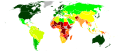
Human Development Index by State

UN flag with equidistant azimuthal projection


history
The table lists early world maps that claimed to depict the entire known world. It extends to the first map that depicts the New World after America was discovered .
| title | Year (approx.) | Author / client | Country / Region (today) | image | The oldest surviving tradition |
|---|---|---|---|---|---|
| Babylonian worldview | 600 BC Chr. | Iraq, Babylon |

|
600 BC Chr. | |
| Orbis Terrarum (Agrippa) | 1 | Marcus Vipsanius Agrippa | |||
| Tabula Peutingeriana | 375 |
|
1150 | ||
| World map of the cosmos of Indicopleustes | 550 | Kosmas Indicopleustes | Egypt, Alexandria |

|
550 |
| Hereford card | 1290 | Richard of Haldingham and Lafford (now Holdingham and Sleaford), known as Richard de Bello | England, Hereford |

|
1290 |
| Ebstorf world map | 1300 | ? | Germany, Ebstorf |

|
1891 |
| Kangnido / Honil Gangni Yeokdae Gukdo Ji Do | 1402 | Korea |

|
||
| De Virga world map | 1411 |

|
1911 | ||
| World map by Andreas Walsperger | 1448 |

|
1448 | ||
| Genoese world map | 1457 | ||||
| Fra Mauros world map | 1459 |

|
|||
| World map by Alberto Cantino | 1502 |
|
|||
| Martin Waldseemüller | 1507 |

|

For the world maps of the Middle Ages see also Mappa mundi and Radkarte .
Important world map projects of the 20th century were the international world map (from 1913) and the world map 1: 2,500,000 (from 1956).
See also
Web links
- Wilhelm Kubitschek : Maps . In: Paulys Realencyclopadie der classischen Antiquity Science (RE). Volume X, 2, Stuttgart 1893ff., Sp. 2022-2149.
Individual evidence
- ↑ Patricia Fara: 4000 years of science , translated by Kamphuis Andrea. Springer Spectrum, 1st edition 2010 (introduction) ISBN 978-3-8274-2545-4