
World map 1: 2,500,000

The world map 1: 2,500,000 (English World Map 1: 2,500,000 , Russian Карта Мира 1: 2,500,000 ) is an internationally edited and standardized map series . It was created from 1956 to 1975.
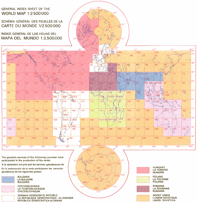
The designation Карта Мира or in the legend Karta Mira for this map series is also common outside of the Soviet Union and Russia. The Karta Mira consists of a total of 224 main sheets and 38 overlapping sheets with a total of 83 m 2 map area. They depict the entire earth (land and water surfaces) according to a uniform color scheme, system of symbols and scale . The latter means that a distance of 1 cm on the map corresponds to 25 km in nature. The proposal for a world map with elevation layers came in 1957 from the Hungarian cartographer Sándor Radó . The Karta Mira was produced between 1956 and 1975 by cartographers from seven socialist countries, specifically Bulgaria , Czechoslovakia , the GDR , Poland , the Soviet Union , Romania and Hungary .
The production of a world map on a scale of 1: 2,500,000 has been discussed since the late 1940s. a. because many cartographers were dissatisfied with the work on the International World Map 1: 1,000,000 (IWK). The IWK had suffered a severe setback with the destruction of the Central Bureau of the Map of the World in London during World War II, leaving it unsure whether the IWK could ever be completed.
Cartographers from Hungary (Sándor Radó, Peter Halasz, E. Földi, Istvan Joo) and from the Soviet Union ( Grigorij A. Ginzburg [Григорий А. Гинзбург], Ilya Andrejewitsch Kutusow [Илвера]) took the initiative to produce the Karta Mira. and from the GDR (Erfried Haack, Horst Nischan, Manfred Pateisat). The production of the 262 sheets was divided among the geodetic services of the participating countries. The sheets to be produced by the GDR were printed by the VEB Hermann Haack Geographisch-Kartographische Anstalt Gotha and the VEB Kombinat Geodesie und Kartographie in Leipzig and Potsdam . The sheets transferred to the Soviet Union were produced by the Main Department of Geodesy and Cartography [Главное Управление геодезии и картографии] in Moscow. Trial prints of several sheets were presented by the East German cartographers involved at an international conference in December 1963 in Erfurt . The first edition of all sheets was complete in 1975.
See also
Web links
- Maps in the map collection of the University of Greifswald
- Map index of the Karta Mira (color shows which country processes which map sheets)
Individual evidence
- ↑ Werner Stams : Karta mira - World Map 1: 2 500 000. In: Lexicon of cartography and geomatics. Spektrum Akademischer Verlag, Heidelberg, 2001, accessed on May 22, 2018 .
- ^ Werner Stams: Sándor Radó. In: Lexicon of Cartography and Geomatics. Spektrum Akademischer Verlag, Heidelberg, 2001, accessed on May 22, 2018 .