Hereford card
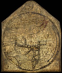
The Hereford map is the largest completely preserved mappa mundi , a medieval map of the world . It was painted at the end of the 13th century , probably between 1285 and 1295, on calf's parchment measuring 135 cm × 165 cm. The author (rather the client) was Richard von Haldingham and Lafford (today Holdingham and Sleaford ), known as Richard de Bello, around 1283 canon of Lincoln and from 1305 beneficiary and canon of the Episcopal Church of Hereford , died after 1313. The card is issued in Hereford and has been part of the world document heritage since 2007 .
As a typical mappa mundi , it is a "world painting" with the aim of depicting creation and salvation history in an instructive way , and therefore has little obligation to geography according to today's understanding. In the map legend, the author Richard (who, unusual in medieval pictures, calls himself by name) turns to the viewer of this story to ask Jesus for grace for him.
description

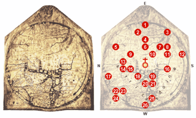
* For a description of all points listed, see the description page of the file.
Like most mappae mundi, the map is circular (132 cm in diameter) and in a modified TO scheme , i.e. h., it shows the continents Asia above Europe the bottom left and Africa lower right, is therefore faces east (east is at the top). At the very top, outside the map, stands Christ, who at the Last Judgment separates the saved (on his right, therefore on the left in the picture) from the damned (right).
The round frame of the actual map image is divided into four by incisions, inscribed with the letters MORS ( mors, Latin: death ) in gold , and adorned with the twelve winds.
Also because of its dimensions (only the lost, but reconstructed Ebstorf map of the world was larger ), the work shows more geographic details than other cycle maps : Indus , Tigris (4) and Euphrates (6) are shown, the Persian Gulf (7) and that (painted in red) Red Sea (8), the Dead Sea with the sunken cities of Sodom and Gomorrah (10), into which the Jordan flows from the Sea of Galilee - above Lot's wife, turning around.
Gog and Magog , embodiment of evil, which according to legend , Alexander the Great separated from humanity by a wall, but which will be liberated by Satan before the Last Judgment (and ultimately defeated by Christ), are on the left edge of the leaf, in the north-northeast , recorded - in the area of the Caspian Sea (5), which is only shown as a gulf of the world ocean (experts such as Crone (lit.) see a delay of up to 200 years between contemporary knowledge and the content of the map).
In the Mediterranean Sea you can find Constantinople (14), to the left of it the Danube Delta , and Troy (15), the islands of Crete (19; roughly incorrectly listed, but with a labyrinth ), Sicily (21) and the Balearic Islands (25).
Among the European cities, in addition to Rome in the imprecisely designed Italy (20), the university city of Paris is particularly emphasized . England (23), Scotland (22) and Ireland (24) are shown in a strongly stylized way for reasons of space . The Pillars of Hercules (the Strait of Gibraltar, 26) lie opposite Paradise on the lower edge of the leaf.
Numerous figurative images (many of them show mythical creatures) and 1091 mostly Latin legends teach the viewer. In Scandinavia, for example, a skier is depicted and described (17). Outside of the map, there are also notes in a dialect of the Old French language. It is not without reason that Dan Terkla (lit.) also sees the map as an “intended tourist attraction of the Middle Ages”.
Christian salvation history
As is customary with such maps, salvation history is given a special space, which is why Palestine is shown in a very oversized manner. Jerusalem , under the crucifix , lies according to Ezekiel V: 5 in the center of the earth, and at the very top is the paradise (1) with the four rivers of paradise depicted as an island surrounded by a wall, including Adam and Eve and the tree of knowledge ; outside, right below, the expulsion. The Arche Noah (9), the Tower of Babel (6; with particularly detailed legend), the flight of the Israelites through the Red Sea (8) and the wandering in the desert will also find place like the Golden Fleece (13).
Own region
It is also common for the map maker to display his own region in more detail than others. Scotland is shown as a separate island, otherwise the British Isles with Ireland are shown relatively well and contain over thirty city names.
Antipodes or fourth continent
Opposite, on the right edge, is an area populated by monsters, separated from Africa by a narrow band of water (12). Although the body of water that runs from one lake to another is described as the “upper reaches of the Nile”, there are also some arguments in favor of understanding it as a symbol of the equatorial ocean , which has been suspected for a thousand years, and the country as an implied Terra Australis . An outermost ocean surrounds the whole.
Similar works
As unique as the Hereford map is, it belongs to a "family" of mappae mundi that can be traced back to common sources: In addition to the Ebstorf map, the map of Heinrich von Mainz from 1110 and the map in an anonymous psalter from 1225 to be mentioned until 1250.
See also
literature
- Evelyn Edson, Emilie Savage-Smith, Anna-Dorothee von den Brincken : The medieval cosmos. Maps of the Christian and Islamic world. Darmstadt 2005, p. 67ff.
- Brigitte English: Ordo orbis terrae. The world view in the mappae mundi of the early and high Middle Ages (= imaginary worlds of the Middle Ages. Volume 3). Berlin 2002, esp. Pp. 450-467.
- Ute Lindgren: Hereford card. In: Lexicon of the Middle Ages. Volume 4, reprint Stuttgart 1999, p. 2152.
- Anna-Dorothee von den Brincken: Cartographic sources. World, sea and regional maps. Brepols 1988.
- Ivan Kupçík: Old Maps. From antiquity to the end of the 19th century. 6th edition. Hanau 1990, ISBN 3-7684-1873-1 .
- Rudolf Simek: Earth and Cosmos in the Middle Ages. The worldview before Columbus. Munich 1992.
- Scott D. Westrem: The Hereford map. A transcription and translation of the legends with commentary. Turnhout, Brepols 2001. (Reduced facsimile of the Hereford mappa mundi; all legends in Latin and English, annotated)
- Dan Terkla: The Original Placement of the Hereford mappa Mundi. In: Imago Mundi: The International Journal for the History of Cartography. Vol. 56, No. 2, 2004, pp. 131-151.
- G. R. Crone: The Hereford Map. In: Royal Geographic Society Journal. 1948, ISBN 0-902447-10-6 .
- Marcia A. Kupfer: Art and optics in the Hereford map: an English mappa mundi, c. 1300 , New Haven; London: Yale University Press, [2016], ISBN 978-0-300-22033-9
Web links
- Edith Titze: Worldview and geographical knowledge at the time of the Hanseatic League
- Scott D. Westrem: Making a Mappa Mundi: The Hereford Map (English)
- Ingrid Baumgärtner : The Perception of Jerusalem on Medieval Maps of the World ( Memento from May 14, 2006 in the Internet Archive ) (PDF; 7.60 MB)
- The Hereford Mappamundi on henry-davis.com (English)

