Terra Australis
Terra Australis (Latin terra "earth, land"; australis "south") is the name of a hypothetical southern continent postulated in antiquity. The name was coined by Claudius Ptolemy (100–175) in his work Geographike Hyphegesis . He believed that all seas were surrounded by land, like the Mediterranean . Ptolemy therefore predicted a large land mass in the south, Terra australis incognita ( old Greek : ἄγνωστος γῆ, ágnōstos gê " unknown land "), which bounded the Indian Ocean and was connected to Africa .
Fictional southern continent

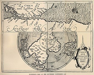
Ancient and medieval cartographers therefore entered a fictional southern continent on their world maps , which stretched from the Indian Ocean to the South Pole . Some still provided this land mass with entries of invented mountains and rivers and often with mythical creatures . According to the idea of the time, it was a continent with a pleasant, warm climate , rich natural resources and a civilized population with whom one could establish trade relations (see also Kerguelen ).
Towards the end of the Middle Ages , interest, aroused by the great voyages of discovery, increasingly turned to the thesis of the existence of a huge, fabulous southern continent. Magellan believed to have discovered the passage between America and the southern continent with the Strait of Magellan in 1520 , which is why the presumed southern continent was subsequently also referred to as Magallanica . However, on his circumnavigation of the world in 1577-80, Francis Drake proved that the Strait of Magellan is not a canal between two continents: he discovered numerous islands in southern South America, and when he finally reached Cape Horn , only the open sea stretched in front of him.
A world map by the Frenchman Guillaume Le Testu from 1555, which was published long before the official discoveries, is puzzling and shows the coast of Western Australia and the mouth of the Fitzroy River precisely. The first sightings of the north and west coast of the fifth continent by the then leading naval power Holland are only recorded in the years around 1600.
Discovery trips around Australia
On May 3, 1606, Pedro Fernández de Quirós reached the New Hebrides (now Vanuatu ). One of these islands, Espiritu Santo , seemed so large to him that he suspected it could be the legendary southern continent, terra australis incognita . He then named the island La Austrialia del Espiritu Santo ("the southern land of the Holy Spirit"). Here he founded the colony Nova Jerusalem .
Also Abel Tasman first believed to be able to find the unknown south land, when he in 1642 for the -company East Indies Dutch on reconnaissance trip to the 1619 sighted Terra incognita departed (Western Australia). On his sea route around Australia , however, he proved instead that this continent does not extend far to the South Pole.
Instead, Charles Bouvet considered Bouvet Island, which he saw in 1739, in the southern Atlantic to be part of the southern continent. Alexander Dalrymple's writings and convictions were the reason for James Cook to investigate the areas around the 60th parallel south. It was not until Cook showed in 1772 with his circumnavigation of the Antarctic that the Indian and Atlantic Oceans merge and the land mass must be considerably smaller, i.e. the postulated Terra Australis does not exist.
This and the naturalization of the name Australia are probably the reasons that Antarctica , as the only real contender, was finally given a different name.
literature
- Relationship between Mr. Petri Fernandes de Quir / Spanish Hauptmans e [t] c. So he is king. May. In Spain e [t] c. Of the newly invented fourth part of the world (so called Terra Australis incognita in Mappis or Landafflen) and the same countries / wealth and fertility e [t] c. passed. Printed in Spanish at Pampelona with the Royal Council permit / now, however, brought into German for good. Bey Chrysostomo Dabertzhofer, Augsburg 1611.
- Gerald Sammet : The world of cards. Historical and modern cartography in dialogue (= Atlantica. The world of maps ). Wissen-Media-Verlag, Gütersloh et al. 2008, ISBN 978-3-577-07251-9 .
- Jules Verne : The Great Navigators and Explorers. A story of the discovery of the earth in the 18th and 19th centuries. Diogenes-Verlag, Zurich 1974, ISBN 3-257-00935-6 , pp. 44–73 (first part, chapter 2: In search of the southern continent ).
Individual evidence
- ↑ The name Magallanica can be found on the world maps by Petrus Plancius 1594 and Willem J. Blaeu 1606 .
- ↑ Relation of Mr. Petri Fernandes de Quir / Spanischen Hauptmans e [t c. So he is king. May. In Spain e [t] c. Of the newly invented fourth part of the world (so called Terra Australis incognita in Mappis or Landafflen) and the same countries / wealth and fertility e [t] c. passed. ] Printed in Spanish at Pampelona with the Royal Council's permit / now brought into German for good. Bey Chrysostomo Dabertzhofer, Augsburg 1611.
