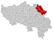
Eupener Land
The northern part of the German-speaking Community in East Belgium , which forms the canton of Eupen, is called Eupener Land . Thus the area of the communities Eupen , Kelmis , Lontzen and Raeren belongs to the Eupener Land. In contrast to the sparsely populated southern part of East Belgium, the Belgian Eifel , the landscape is more densely populated: With a population of over 47,000, the canton of Eupen has around 210 inhabitants per km².
In addition to the eponymous city of Eupen, the settlement structure is characterized by numerous villages, between which there is mostly agricultural grassland. In the southern parts of the municipalities of Eupen and Raeren there are large forest areas and the Wesertalsperre , one of the largest lakes in Belgium. The landscape rises to the south and merges into the High Fens . The high-speed railway line HSL 3 and the Autobahn 3 from Liège to Aachen run right through the Eupener Land .
See also
Individual evidence
- ^ German-speaking community : location and scope, accessed on August 2, 2019.
- ↑ DGSTAT : Population structure, accessed on November 26, 2015.
Coordinates: 50 ° 40 ′ 0 ″ N , 6 ° 4 ′ 40 ″ E


